IMAGES TAKEN NEAR TO
Tyfica Road, PONTYPRIDD, CF37 2DB
Introduction
This page details the photographs taken nearby to Tyfica Road, CF37 2DB by members of the Geograph project.
The Geograph project started in 2005 with the aim of publishing, organising and preserving representative images for every square kilometre of Great Britain, Ireland and the Isle of Man.

There are currently over 7.5m images from over14,400 individuals and you can help contribute to the project by visiting https://www.geograph.org.uk
Image Map
Images are licensed for reuse under creativecommons.org/licenses/by-sa/2.0
Notes
- Clicking on the map will re-center to the selected point.
- The higher the marker number, the further away the image location is from the centre of the postcode.
Image Listing (137 Images Found)
Images are licensed for reuse under creativecommons.org/licenses/by-sa/2.0
Image
Details
Distance
1
Railway underpass, Pontypridd
Viewed from Pontypridd Bus Station on a grey, drizzly day in November 2020.
The path under the bridge leads to Lanpark Road.
Image: © Jaggery
Taken: 21 Nov 2020
0.07 miles
2
Tyfica Crescent, Pontypridd
90 metre long dead-end street viewed from Thomas Street.
The grey fence on the right encloses an electricity substation. http://www.geograph.org.uk/photo/4258505
Image: © Jaggery
Taken: 25 Nov 2014
0.07 miles
3
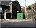
Electricity substation near Pontypridd bus station
The Western Power Distribution electricity substation is at a bend
in Chapel Street, the exit road from Pontypridd bus station to Gelliwastad Road.
Image: © Jaggery
Taken: 16 Apr 2015
0.09 miles
4
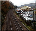
Goods Yard Car Park, Pontypridd
Former railway goods yard viewed from this http://www.geograph.org.uk/photo/2404613 bridge. Since October 2012, Rhondda Cynon Taf Council retains the right to manage and enforce only the lower section of this car park near and behind the Bowls Centre. All Council parking bays are clearly marked with blue bay markings. The rest of the Goods Yard Car Park comes under the management and enforcement of Euro Car Parks.
Image: © Jaggery
Taken: 25 Nov 2014
0.09 miles
5
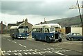
Two generations apart, Pontypridd ? 1979
A remarkable view of two buses owned by the same operator but with an age gap of 30 years. On the left is no.25, a Leyland National new in 1977, on the right 51 is a Bristol L with Beadle bodywork new in 1947 which somehow managed to survive with its original owner for over 30 years, with a couple of withdrawals and re-instatements. It survived into preservation and in 2022 forms part of a fleet of classic buses in Belgium.
This is one of a series of views featuring buses in the 60s, 70s, and 80s. http://www.geograph.org.uk/search.php?i=137652761
Instead of the bus layby, there is now a purpose built bus station at this location https://www.geograph.org.uk/photo/2404628
Image: © Alan Murray-Rust
Taken: 21 Apr 1979
0.09 miles
6
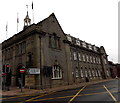
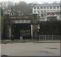
Municipal Buildings, Pontypridd
On the corner of Chapel Street (on the left) and the A4223 Gelliwastad Road.
Image: © Jaggery
Taken: 25 Nov 2014
0.10 miles
7
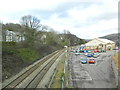
Railway line, seen from Gelliwastad Grove, Pontypridd
The line follows the Taff Vale to Abercynon, then forks to Aberdare and Merthyr Tydfil.
Image: © John Lord
Taken: 3 Mar 2012
0.10 miles
8
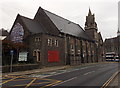
Muni Arts Centre, Pontypridd
In a former Wesleyan chapel in Gelliwastad Road in the centre of Pontypridd.
Later a municipal hall, the building was converted to its current use in the 1980s.
Image: © Jaggery
Taken: 25 Nov 2014
0.10 miles
9

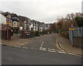
Chapel Street, Pontypridd
A Stagecoach bus on its way to Cardiff emerges from Chapel Street before turning into Gelliwastad Road.
Image: © Stephen McKay
Taken: 30 May 2016
0.10 miles
10
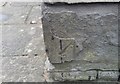
Ordnance Survey Cut Mark
This damaged OS cut mark can be found on the Municipal Hall. It marks a point 65.727m above mean sea level.
Image: © Adrian Dust
Taken: 24 Jun 2017
0.10 miles