IMAGES TAKEN NEAR TO
Tyfica Crescent, PONTYPRIDD, CF37 2BU
Introduction
This page details the photographs taken nearby to Tyfica Crescent, CF37 2BU by members of the Geograph project.
The Geograph project started in 2005 with the aim of publishing, organising and preserving representative images for every square kilometre of Great Britain, Ireland and the Isle of Man.

There are currently over 7.5m images from over14,400 individuals and you can help contribute to the project by visiting https://www.geograph.org.uk
Image Map
Images are licensed for reuse under creativecommons.org/licenses/by-sa/2.0
Notes
- Clicking on the map will re-center to the selected point.
- The higher the marker number, the further away the image location is from the centre of the postcode.
Image Listing (191 Images Found)
Images are licensed for reuse under creativecommons.org/licenses/by-sa/2.0
Image
Details
Distance
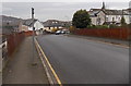
1
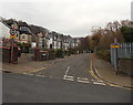
Tyfica Crescent, Pontypridd
90 metre long dead-end street viewed from Thomas Street.
The grey fence on the right encloses an electricity substation. http://www.geograph.org.uk/photo/4258505
Image: © Jaggery
Taken: 25 Nov 2014
0.02 miles
2
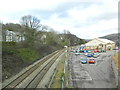
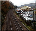
Railway line, seen from Gelliwastad Grove, Pontypridd
The line follows the Taff Vale to Abercynon, then forks to Aberdare and Merthyr Tydfil.
Image: © John Lord
Taken: 3 Mar 2012
0.04 miles
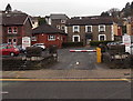
3
Tyfica Crescent electricity substation, Pontypridd
In a fenced enclosure of the corner of Thomas Street and Tyfica Crescent.
The identifier on the Western Power Distribution electricity substation is
TYFICA CRES PONTYPRIDD S/S 541133.
Image: © Jaggery
Taken: 25 Nov 2014
0.04 miles
4
Goods Yard Car Park, Pontypridd
Former railway goods yard viewed from this http://www.geograph.org.uk/photo/2404613 bridge. Since October 2012, Rhondda Cynon Taf Council retains the right to manage and enforce only the lower section of this car park near and behind the Bowls Centre. All Council parking bays are clearly marked with blue bay markings. The rest of the Goods Yard Car Park comes under the management and enforcement of Euro Car Parks.
Image: © Jaggery
Taken: 25 Nov 2014
0.05 miles
5
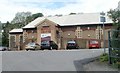
Pontypridd Indoor Bowls Centre
Or Indoor Bowling Centre - the large orange letters disagree with the name sign below. Located in a converted railway building in the Old Goods Yard (surrounded by Goods Yard car park), on the west side of Gelliwastad Road (A4223).
Image: © Jaggery
Taken: 11 May 2011
0.05 miles
6
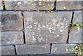
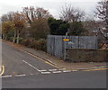
Ordnance Survey Cut Mark
This OS cut mark can be found on the wall SW side of Thomas Street. It marks a point 77.224m above mean sea level.
Image: © Adrian Dust
Taken: 23 Jun 2018
0.06 miles
7
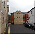
Gelliwastad Court, Pontypridd
Flats at the northern end of Library Road. A notice on the wall shows CAUTION - CHILDREN AT PLAY.
Image: © Jaggery
Taken: 25 Nov 2014
0.06 miles
8
Across Thomas Street railway bridge, Pontypridd
Looking towards Gelliwastad Grove across this http://www.geograph.org.uk/photo/2404613 bridge over a railway.
Image: © Jaggery
Taken: 25 Nov 2014
0.06 miles
9
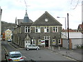
Entrance to Gelliwastad Club and Institute, Pontypridd
From Gelliwastad Road. This is a private club, members only. Membership is available.
Image: © Jaggery
Taken: 25 Nov 2014
0.08 miles