1
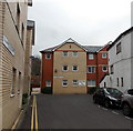
Gelliwastad Court, Pontypridd
Flats at the northern end of Library Road. A notice on the wall shows CAUTION - CHILDREN AT PLAY.
Image: © Jaggery
Taken: 25 Nov 2014
0.01 miles
2
Pontypridd Indoor Bowls Centre
Or Indoor Bowling Centre - the large orange letters disagree with the name sign below. Located in a converted railway building in the Old Goods Yard (surrounded by Goods Yard car park), on the west side of Gelliwastad Road (A4223).
Image: © Jaggery
Taken: 11 May 2011
0.02 miles
3
Entrance to Gelliwastad Club and Institute, Pontypridd
From Gelliwastad Road. This is a private club, members only. Membership is available.
Image: © Jaggery
Taken: 25 Nov 2014
0.02 miles
4
Railway line, seen from Gelliwastad Grove, Pontypridd
The line follows the Taff Vale to Abercynon, then forks to Aberdare and Merthyr Tydfil.
Image: © John Lord
Taken: 3 Mar 2012
0.02 miles
5
Library, Pontypridd
Image: © John Lord
Taken: 3 Mar 2012
0.03 miles
6
Across Thomas Street railway bridge, Pontypridd
Looking towards Gelliwastad Grove across this http://www.geograph.org.uk/photo/2404613 bridge over a railway.
Image: © Jaggery
Taken: 25 Nov 2014
0.03 miles
7
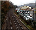
Goods Yard Car Park, Pontypridd
Former railway goods yard viewed from this http://www.geograph.org.uk/photo/2404613 bridge. Since October 2012, Rhondda Cynon Taf Council retains the right to manage and enforce only the lower section of this car park near and behind the Bowls Centre. All Council parking bays are clearly marked with blue bay markings. The rest of the Goods Yard Car Park comes under the management and enforcement of Euro Car Parks.
Image: © Jaggery
Taken: 25 Nov 2014
0.03 miles
8
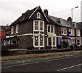
Apex in Pontypridd
Estate agents at 6 Gelliwastad Road.
Image: © Jaggery
Taken: 25 Nov 2014
0.03 miles
9
Citizens Advice Bureau in Pontypridd
At 5 Gelliwastad Road. Apex estate agents office http://www.geograph.org.uk/photo/4259451 is next door.
Image: © Jaggery
Taken: 25 Nov 2014
0.04 miles
10
Llwyn Castan in Pontypridd
Llwyn Castan is Rhondda Cynon Taf Council's Environmental Services office in Library Road.
Text on the side of the Openreach van shows 'A BT Group business'.
Openreach is the infrastructure division of the telecommunications company.
Image: © Jaggery
Taken: 25 Nov 2014
0.04 miles


