1
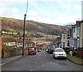
Ruler Way, Treforest, Pontypridd
Viewed from Princess Street. Ruler Way is a street of recently-built houses on the site
formerly occupied by Treforest Primary School for more than a century. http://www.geograph.org.uk/photo/3395980
Image: © Jaggery
Taken: 12 Jan 2012
0.01 miles
2
Treforest Primary School plaque, Pontypridd
The plaque is on a wall here. http://www.geograph.org.uk/photo/3395976
Image: © Jaggery
Taken: 12 Jan 2012
0.02 miles
3
Princess Street, Treforest, Pontypridd
This is the NW end of Princess Street, viewed across Stow Hill.
Image: © Jaggery
Taken: 12 Jan 2012
0.03 miles
4
The Red Lounge, Treforest
Restaurant and theme bar at 71 Wood Road.
The premises were formerly occupied by Tom's Entertainment Venue.
Image: © Jaggery
Taken: 9 Dec 2011
0.04 miles
5
Tesco Express, Treforest
Recently-built premises located in Broadway Retail Park, set back from the north side of Broadway, Treforest. Opening times displayed on the building are 6am to 11pm (seven days a week).
Image: © Jaggery
Taken: 9 Dec 2011
0.04 miles
6
The Railway Inn, Treforest
Formerly The Golden Age, located on the corner of Broadway and Cambrian Place.
Image: © Jaggery
Taken: 9 Dec 2011
0.04 miles
7
Down Stow Hill, Treforest, Pontypridd
Stow Hill descends towards Tower Street.
Image: © Jaggery
Taken: 12 Jan 2012
0.04 miles
8
Corner of Tower Street and Stow Hill, Pontypridd
A triangular hedge occupies the corner of Tower Street on the right and Stow Hill on the left.
Image: © Jaggery
Taken: 12 Jan 2012
0.05 miles
9
Parc Lewis Primary School, Treforest
The school is on the NE side of Broadway.
Image: © Jaggery
Taken: 9 Dec 2011
0.06 miles
10
Groggs, Treforest
Premises at 159-160 Broadway, Treforest.
Established in 1965, Groggs design, create and sell hand-sculpted figurine caricatures of subjects such as miners, sports celebrities, film stars and pop stars. There are also humorous figurines of sheep and dragons.
Now exported to many countries, Groggs were first designed and made by John Hughes, who became famous in 1971 for his figurines of rugby stars Gareth Edwards and JPR Williams. Groggs auctions have raised thousands of pounds for charity.
Image: © Jaggery
Taken: 9 Dec 2011
0.06 miles


