IMAGES TAKEN NEAR TO
Park Street, PONTYPRIDD, CF37 1SL
Introduction
This page details the photographs taken nearby to Park Street, CF37 1SL by members of the Geograph project.
The Geograph project started in 2005 with the aim of publishing, organising and preserving representative images for every square kilometre of Great Britain, Ireland and the Isle of Man.

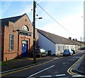
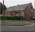
There are currently over 7.5m images from over14,400 individuals and you can help contribute to the project by visiting https://www.geograph.org.uk
Image Map
Images are licensed for reuse under creativecommons.org/licenses/by-sa/2.0
Notes
- Clicking on the map will re-center to the selected point.
- The higher the marker number, the further away the image location is from the centre of the postcode.
Image Listing (206 Images Found)
Images are licensed for reuse under creativecommons.org/licenses/by-sa/2.0
Image
Details
Distance
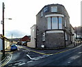
1
West side of the Otley Arms, Treforest
Forest Road side of the pub on the corner of Meadow Street. https://www.geograph.org.uk/photo/3427758
Image: © Jaggery
Taken: 1 Mar 2019
0.00 miles
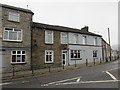
2
Otley Arms, Treforest
Pub on the corner of Forest Road and Meadow Street. Long Row houses are on the left.
Image: © Jaggery
Taken: 12 Jan 2012
0.01 miles
3
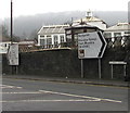
Park Street direction signs in Treforest
Opposite the Forest Road junction.
Right along Park Street for Pontypridd and the Rhondda Valleys (Cwm Rhondda in Welsh).
Left for Llantrisant, the university and Treforest Park & Ride.
Image: © Jaggery
Taken: 1 Mar 2019
0.01 miles
4
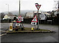
Temporary road signs on a triangle in Treforest
In place on March 1st 2019 at the junction of Forest Road
and Park Street on the approach to this part https://www.geograph.org.uk/photo/6077086 of Park Street.
Image: © Jaggery
Taken: 1 Mar 2019
0.02 miles
5
Long Row Audio recording studio, Treforest, Pontypridd
Recording studio and rehearsal rooms in a converted former Salvation Army Chapel.
The location is on the corner of Forest Road, next to a long row of houses named Long Row.
Image: © Jaggery
Taken: 12 Jan 2012
0.02 miles
6
Long Row Audio in Treforest
Recording studio and rehearsal rooms in a converted former Salvation Army Chapel.
Located on the corner of Forest Road and Meadow Street near a long row of houses named Long Row.
Image: © Jaggery
Taken: 1 Mar 2019
0.02 miles
7
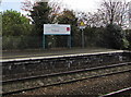
Bilingual information on Treforest railway station
The sign shows "Treforest Alight here for the University of South Wales" and its Welsh equivalent.
Treforest is Trefforest in Welsh.
Image: © Jaggery
Taken: 20 Oct 2017
0.03 miles
8
Blue bus shelter near the Otley Arms, Treforest
Alongside Forest Road. The Otley Arms pub https://www.geograph.org.uk/photo/3427758 is on the right.
Image: © Jaggery
Taken: 1 Mar 2019
0.03 miles
9
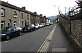
Residential part of Park Street, Treforest
These houses opposite Treforest railway station are south of the Castle Street junction.
Park Street shops and other businesses are north of the Castle Street junction.
Image: © Jaggery
Taken: 9 Apr 2018
0.03 miles
10
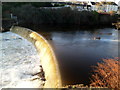
Treforest Weir
Looking west from first floor steps on a Cardiff Road (A4054) building.
The River Taff tumbles noisily down the weir, located 100 metres south of Castle Bridge. http://www.geograph.org.uk/photo/2752680
Image: © Jaggery
Taken: 9 Dec 2011
0.04 miles