IMAGES TAKEN NEAR TO
Duke Street, PONTYPRIDD, CF37 1RT
Introduction
This page details the photographs taken nearby to Duke Street, CF37 1RT by members of the Geograph project.
The Geograph project started in 2005 with the aim of publishing, organising and preserving representative images for every square kilometre of Great Britain, Ireland and the Isle of Man.

There are currently over 7.5m images from over14,400 individuals and you can help contribute to the project by visiting https://www.geograph.org.uk
Image Map
Images are licensed for reuse under creativecommons.org/licenses/by-sa/2.0
Notes
- Clicking on the map will re-center to the selected point.
- The higher the marker number, the further away the image location is from the centre of the postcode.
Image Listing (138 Images Found)
Images are licensed for reuse under creativecommons.org/licenses/by-sa/2.0
Image
Details
Distance
1
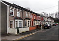
Oxford Street houses, Treforest
Houses on the west side of the street, north of the fire station. http://www.geograph.org.uk/photo/3831104
Image: © Jaggery
Taken: 30 Jan 2014
0.03 miles
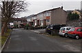
2
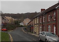
SW end of Duke Street, Treforest
Looking along Duke Street past the left turn for Park Close http://www.geograph.org.uk/photo/3831132 towards Birchley Close. http://www.geograph.org.uk/photo/3831124
Image: © Jaggery
Taken: 30 Jan 2014
0.03 miles
3
Birchley Close, Treforest
Viewed from the Duke Street end.
Image: © Jaggery
Taken: 30 Jan 2014
0.04 miles
4
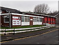
Pontypridd Fire Station viewed from the south, Treforest
Viewed across Oxford Street, Treforest. Part of the South Wales Fire and Rescue Service, Pontypridd Fire Station serves the main town of Pontypridd and surrounding villages, such as Church Village, Ynysybwl and Rhydfelin. The station was officially opened in July 1965.
Image: © Jaggery
Taken: 30 Jan 2014
0.05 miles
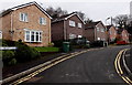
5
Park Close, Treforest
Viewed from the corner of Duke Street and Birchley Close. Park Close leads to Cwrt Glyndwr.
Image: © Jaggery
Taken: 30 Jan 2014
0.06 miles
6
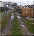
Puddly track in Treforest
Viewed from Brook Street looking towards Duke Street. The track is between King Street and Queen Street.
Image: © Jaggery
Taken: 30 Jan 2014
0.06 miles
7
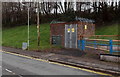
King Street electricity substation in Treforest
The identifier on the Western Power Distribution substation shows King Street Treforest S/S 541736, though it is located alongside Duke Street, a few metres from the corner of King Street.
Image: © Jaggery
Taken: 30 Jan 2014
0.06 miles
8
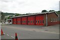
Pontypridd Fire Station
Pontypridd Fire Station, Oxford Street, Treforest, Pontypridd - part of South Wales Fire & Rescue Service
Image: © Kevin Hale
Taken: 4 Jun 2007
0.06 miles
9
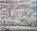
Ordnance Survey Cut Mark
This OS cut mark can be found on No83 King Street. It marks a point 78.992m above mean sea level.
Image: © Adrian Dust
Taken: 23 Jun 2018
0.07 miles
10
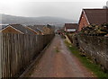
Down the Pontypridd Circular Walk towards Brook Street, Treforest
This is a public footpath but a private drive (only residents' cars allowed).
Image: © Jaggery
Taken: 30 Jan 2014
0.07 miles