IMAGES TAKEN NEAR TO
Rickards Street, PONTYPRIDD, CF37 1RE
Introduction
This page details the photographs taken nearby to Rickards Street, CF37 1RE by members of the Geograph project.
The Geograph project started in 2005 with the aim of publishing, organising and preserving representative images for every square kilometre of Great Britain, Ireland and the Isle of Man.

There are currently over 7.5m images from over14,400 individuals and you can help contribute to the project by visiting https://www.geograph.org.uk
Image Map
Images are licensed for reuse under creativecommons.org/licenses/by-sa/2.0
Notes
- Clicking on the map will re-center to the selected point.
- The higher the marker number, the further away the image location is from the centre of the postcode.
Image Listing (187 Images Found)
Images are licensed for reuse under creativecommons.org/licenses/by-sa/2.0
Image
Details
Distance
1
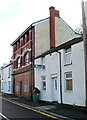
44 Rickards Street, Pontypridd
3 storeys high, 44 Rickards Street is conspicuously unlike neighbouring properties.
Now in residential use, it was probably once a shop or pub.
Image: © Jaggery
Taken: 12 Jan 2012
0.01 miles
2
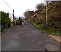
Towards the eastern end of Graig Terrace, Graig, Pontypridd
Not a through route.
Image: © Jaggery
Taken: 19 Nov 2014
0.03 miles
3
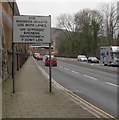
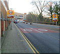
For Rhondda Valleys Use Both Lanes, Pontypridd
The sign faces westbound traffic on the A4058. The text is also in Welsh.
Image: © Jaggery
Taken: 8 Mar 2019
0.04 miles
4
SE boundary of Pontypridd Town
Broadway reaches the boundary of Pontypridd Town, part of the Pontypridd community in Rhondda Cynon Taf, Wales. The 2001 UK Census recorded the population of Pontypridd community as 29,781 of which Pontypridd Town contributed 2,919 inhabitants.
Pontypridd is often referred to locally as "Ponty".
Image: © Jaggery
Taken: 9 Dec 2011
0.06 miles
5
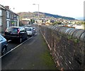
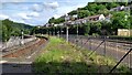
Railway perimeter wall, Rickards Street, Pontypridd
The long wall on the north side of Rickards Street is at the edge of (and several metres above)
railway lines east of Pontypridd railway station.
Image: © Jaggery
Taken: 12 Jan 2012
0.06 miles
6
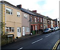
Mitchells Terrace, Pontypridd
Mitchells Terrace is a separately-named row of houses on the north side of Rickards Street.
Image: © Jaggery
Taken: 12 Jan 2012
0.06 miles
7
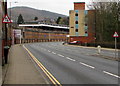
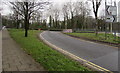
End of the dual carriageway, Broadway, Pontypridd
Two-way traffic signs are alongside the A4058 here named Broadway.
The high wall is at the edge of the railway on the approach to Pontypridd railway station.
Image: © Jaggery
Taken: 8 Mar 2019
0.06 miles
8
From Broadway to the A4058, Pontypridd
The A4058 ahead is on the south bank of the River Taff.
Image: © Jaggery
Taken: 8 Mar 2019
0.07 miles
9
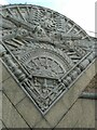
Relief sculpture, wall between road and railway, Pontypridd
Image: © David Smith
Taken: 21 Sep 2022
0.08 miles