IMAGES TAKEN NEAR TO
Llys Graig Y Wion, PONTYPRIDD, CF37 1NZ
Introduction
This page details the photographs taken nearby to Llys Graig Y Wion, CF37 1NZ by members of the Geograph project.
The Geograph project started in 2005 with the aim of publishing, organising and preserving representative images for every square kilometre of Great Britain, Ireland and the Isle of Man.

There are currently over 7.5m images from over14,400 individuals and you can help contribute to the project by visiting https://www.geograph.org.uk
Image Map
Images are licensed for reuse under creativecommons.org/licenses/by-sa/2.0
Notes
- Clicking on the map will re-center to the selected point.
- The higher the marker number, the further away the image location is from the centre of the postcode.
Image Listing (299 Images Found)
Images are licensed for reuse under creativecommons.org/licenses/by-sa/2.0
Image
Details
Distance
1
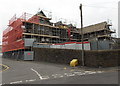
Scaffolding on a former primary school in Pontypridd
The corner of Albert Road and Court House Street in early May 2014.
This was Graig-y-wion County Primary School which closed in 2006.
Image: © Jaggery
Taken: 3 May 2014
0.01 miles
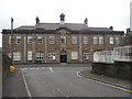
2
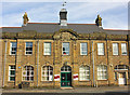
Pontypridd County Court
Located at the far (NW) end of Courthouse Street. The County Court deals with legal aspects of civil cases, bankruptcy, adoption, care, family work and divorce. The County Court is also used by the Queen's Bench Division, which deals mainly with areas such as
● claims for damages in respect of personal injury, negligence,
breach of contract, and defamation (libel and slander).
● non-payment of a debt.
● possession of land or property.
Image: © Jaggery
Taken: 9 Dec 2011
0.02 miles
3
Devonalds, Pontypridd
Solicitors' offices in York House,Courthouse Street, opposite Pontypridd County Court. http://www.geograph.org.uk/photo/2757941
Image: © Jaggery
Taken: 9 Dec 2011
0.02 miles
4
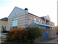
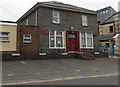
Pontypridd Register Office
Built in 1913 from coursed rock-faced stone.
Image: © Wayland Smith
Taken: 5 Nov 2011
0.04 miles
6
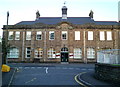
Former Register Office, Pontypridd
Viewed from Albert Road. This large building on Courthouse Street has the year 1913 engraved in stone above the central first floor window. Formerly the Register Office, it is now the offices of Rhondda Cynon Taf's Community & Children's Services.
Pontypridd's Register Office is now (early January 2012) in Municipal Buildings, Gelliwastad Road.
Image: © Jaggery
Taken: 9 Dec 2011
0.05 miles
7
High Street passing underneath Pontypridd railway station
Viewed from the north side, across Sardis Road.
Image: © Jaggery
Taken: 21 Apr 2010
0.05 miles
8
Corner of High Street and Sardis Road, Pontypridd
Sardis Road is on the left, High Street is on the right. There are To Let signs on the corner building.
Image: © Jaggery
Taken: 9 Dec 2011
0.05 miles
9
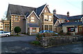
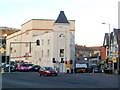
Glenview House, Pontypridd
Viewed across Court House Street. There are two nameplates on the building. The one on the left shows Wales Council for Deaf People. The one on the right shows A1 Conference Centre.
There were Offices to Let notices on the windows at the early May 2014 date of this view.
Image: © Jaggery
Taken: 3 May 2014
0.05 miles
10
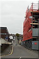
Albert Road, Pontypridd
Looking SW from Court House Street in early May 2014. The scaffolding is on a former school. http://www.geograph.org.uk/photo/3960450
Image: © Jaggery
Taken: 3 May 2014
0.05 miles