IMAGES TAKEN NEAR TO
Brynhyfryd Place, PONTYPRIDD, CF37 1NP
Introduction
This page details the photographs taken nearby to Brynhyfryd Place, CF37 1NP by members of the Geograph project.
The Geograph project started in 2005 with the aim of publishing, organising and preserving representative images for every square kilometre of Great Britain, Ireland and the Isle of Man.

There are currently over 7.5m images from over14,400 individuals and you can help contribute to the project by visiting https://www.geograph.org.uk
Image Map
Images are licensed for reuse under creativecommons.org/licenses/by-sa/2.0
Notes
- Clicking on the map will re-center to the selected point.
- The higher the marker number, the further away the image location is from the centre of the postcode.
Image Listing (80 Images Found)
Images are licensed for reuse under creativecommons.org/licenses/by-sa/2.0
Image
Details
Distance
1

Two shops on the corner of Tower Street and Laura Street, Pontypridd
The shop on the right, with a TO LET board on the door, was formerly the premises of Crafty Changes,
a craft shop. The shop on the left shows the name Hazel's. The windows are shuttered (early Thursday afternoon) and a board showing a phone number is badly faded. Formerly a hairdressers, perhaps?
Image: © Jaggery
Taken: 12 Jan 2012
0.02 miles
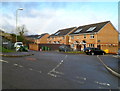
2
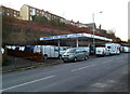
Broadway Van Centre, Treforest
Located near the western end of Broadway. The part of the premises in view was formerly a Total fuel filling station.
Image: © Jaggery
Taken: 9 Dec 2011
0.02 miles
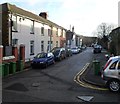
3

Tower Street, Pontypridd
Tower Street climbs away from Stow Hill.
Image: © Jaggery
Taken: 12 Jan 2012
0.06 miles
4
Cliff Terrace, Pontypridd
A view SE from the edge of a former synagogue. http://www.geograph.org.uk/photo/3208830
Image: © Jaggery
Taken: 12 Jan 2012
0.06 miles
5
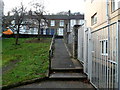
Ramp from Cliff Terrace to Wood Road, Pontypridd
Viewed from near the former Pontypridd Synagogue. http://www.geograph.org.uk/photo/3208830
Image: © Jaggery
Taken: 12 Jan 2012
0.06 miles
6
Ordnance Survey Cut Mark
This OS cut mark can be found at the junction of Wood Road & Cliff Terrace. It marks a point 85.341m above mean sea level.
Image: © Adrian Dust
Taken: 23 Jun 2018
0.06 miles
7
Pen yr Ysgol houses, Treforest, Pontypridd
Recently-built houses viewed from the top of Stow Hill.
Image: © Jaggery
Taken: 12 Jan 2012
0.07 miles
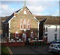
8

Calvary, a church on a hill, Treforest
Calvary Baptist Church, Cliff Terrace, viewed from Broadway. The church was built in 1851-1852 as Calvary English Baptist Church, "English" signifying the language used for the services in an era when Welsh was more widely spoken in Treforest than it is today. When the church first opened, the surrounding area was heavily wooded, with very few dwellings nearby. It was considered a dangerous place to be at night.
Image: © Jaggery
Taken: 9 Dec 2011
0.08 miles
9
Former Pontypridd Synagogue
The former synagogue at the NW end of Cliff Terrace is now in residential use.
Image: © Jaggery
Taken: 12 Jan 2012
0.08 miles
10
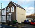
House formerly part of St Michael's School, Pontypridd
The house, on the north side of Wood Road, was formerly part of the otherwise demolished St Michael's Catholic School. There is an inscription of three lines on a tablet on the wall between the two rows of windows. The first line has been obliterated. The second and third lines are GRAMMAR SCHOOL and 1875. This cannot refer to St Michael's, which was not a grammar school and did not occupy this site until 1883. The house was for a time the residence of the school caretaker.
Image: © Jaggery
Taken: 12 Jan 2012
0.08 miles