IMAGES TAKEN NEAR TO
Gelliwion Road, PONTYPRIDD, CF37 1EY
Introduction
This page details the photographs taken nearby to Gelliwion Road, CF37 1EY by members of the Geograph project.
The Geograph project started in 2005 with the aim of publishing, organising and preserving representative images for every square kilometre of Great Britain, Ireland and the Isle of Man.

There are currently over 7.5m images from over14,400 individuals and you can help contribute to the project by visiting https://www.geograph.org.uk
Image Map
Images are licensed for reuse under creativecommons.org/licenses/by-sa/2.0
Notes
- Clicking on the map will re-center to the selected point.
- The higher the marker number, the further away the image location is from the centre of the postcode.
Image Listing (24 Images Found)
Images are licensed for reuse under creativecommons.org/licenses/by-sa/2.0
Image
Details
Distance
1
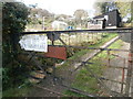
Allotments, Gelliwion Rd, Maesycoed, Pontypridd
Image: © John Lord
Taken: 30 Oct 2017
0.09 miles
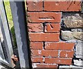
3
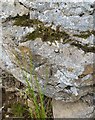
Ordnance Survey Rivet
This OS rivet can be found on a rock west side of the track. It marks a point 223.476m above mean sea level.
Image: © Adrian Dust
Taken: 23 Jun 2018
0.11 miles
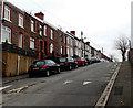
4
Llanfair Road, Maesycoed, Pontypridd
Viewed across Lanwern Road.
Image: © Jaggery
Taken: 19 Nov 2014
0.16 miles
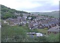
5
Maesycoed
Viewed from Llantrisant Road, Graig.
Image: © Roger Cornfoot
Taken: 25 Apr 2007
0.16 miles
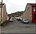
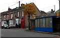
6
Lanwern Road houses north of Llanfair Road, Pontypridd
The houses face Maes-y-Coed Primary School. Some online sources show Llanwern Road,
but maps I consulted and the street name signs here show Lanwern Road.
Image: © Jaggery
Taken: 19 Nov 2014
0.20 miles
7
Ordnance Survey Cut Mark
This OS cut mark can be found on the school wall, Lanwern Road. It marks a point 104.382m above mean sea level.
Image: © Adrian Dust
Taken: 23 Jun 2018
0.21 miles
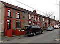
8
Lanwern Road, Maesycoed, Pontypridd
The houses on the west side of the street are opposite Maes-y-Coed Primary School. Some online sources show Llanwern Road, but maps I consulted and the street name signs here show Lanwern Road.
Image: © Jaggery
Taken: 19 Nov 2014
0.21 miles
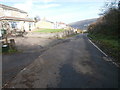
9
Bilingual welcome at the entrance to Maes-y-Coed Primary School, Pontypridd
From Lanwern Road. Welcome and English text on the left side, Croeso and Welsh text on the right.
Image: © Jaggery
Taken: 19 Nov 2014
0.21 miles
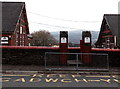
10
Blue bus shelter and red phonebox in Maesycoed, Pontypridd
Near the northern end of Lanwern Road, viewed from the corner of Mound Road.
Image: © Jaggery
Taken: 19 Nov 2014
0.21 miles