IMAGES TAKEN NEAR TO
Sardis Road, PONTYPRIDD, CF37 1DX
Introduction
This page details the photographs taken nearby to Sardis Road, CF37 1DX by members of the Geograph project.
The Geograph project started in 2005 with the aim of publishing, organising and preserving representative images for every square kilometre of Great Britain, Ireland and the Isle of Man.

There are currently over 7.5m images from over14,400 individuals and you can help contribute to the project by visiting https://www.geograph.org.uk
Image Map
Images are licensed for reuse under creativecommons.org/licenses/by-sa/2.0
Notes
- Clicking on the map will re-center to the selected point.
- The higher the marker number, the further away the image location is from the centre of the postcode.
Image Listing (340 Images Found)
Images are licensed for reuse under creativecommons.org/licenses/by-sa/2.0
Image
Details
Distance
1
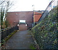
Sardis Public Toilets, Pontypridd
Set below road level on the east side of Sardis Road.
The Welsh for public toilets shown on the sign is Tai-bach, literally little houses.
Image: © Jaggery
Taken: 12 Jan 2012
0.01 miles
2
Thomas Recruitment office in Pontypridd
In Thomas House, 13-15 Sardis Road.
Image: © Jaggery
Taken: 25 Nov 2014
0.01 miles
3

Rhondda flows towards Taff Street and the River Taff, Pontypridd
Viewed from near the northern end of Sardis Road, looking ESE. A few metres after flowing under Taff Street ahead, the Rhondda flows into the River Taff http://www.geograph.org.uk/photo/3450638 at the edge of Ynysangharad Park.
Image: © Jaggery
Taken: 25 Nov 2014
0.01 miles
4
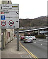
Information and directions sign, Sardis Road, Pontypridd
Alongside the A4058 Sardis Road. Pontypridd railway station is in the background.
Image: © Jaggery
Taken: 9 Apr 2018
0.02 miles
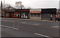
5
Stardust Bingo, Pontypridd
The Sardis Road side of the bingo hall at 75-77 High Street.
Image: © Jaggery
Taken: 25 Nov 2014
0.02 miles
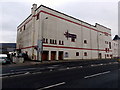
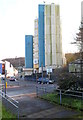
6
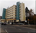
Sardis House, Pontypridd
Sardis House is a Rhondda Cynon Taf council multi-storey building in Sardis Road, near Pontypridd railway station. A large board above the entrance shows One4All, which is defined by the council's website as a one-stop shop approach to council services, "so that you can get access to advice and information, in person, in one simple visit without being passed from pillar to post!"
Image: © Jaggery
Taken: 25 Nov 2014
0.02 miles
7
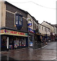
Kraft Kabin, Pontypridd
The shop at 2 High Street sells wool, fabric, ribbon, buttons and other haberdashery.
Image: © Jaggery
Taken: 25 Nov 2014
0.03 miles
8
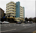
Sardis House, Sardis Road, Pontypridd
Rhondda Cynon Taf council multistorey office building near Pontypridd railway station.
Image: © Jaggery
Taken: 9 Apr 2018
0.03 miles
9
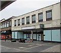
Vacant shop to let, Taff Street, Pontypridd
At the southern end of Taff Street near High Street viewed in April 2018.
Image: © Jaggery
Taken: 9 Apr 2018
0.03 miles
10
Sardis House, Pontypridd
Sardis House is a multi-storey office block in Sardis Road, near Pontypridd railway station.
Rhondda Cynon Taff council's Pontypridd One4All Centre is located on the ground floor.
The council's website defines a One4all Centre as a one-stop shop approach to council services,
"so that you can get access to advice and information, in person,
in one simple visit without being passed from pillar to post!"
The council's other One4all Centres are in Aberdare, Mountain Ash, Porth and Treorchy.
Image: © Jaggery
Taken: 12 Jan 2012
0.03 miles