IMAGES TAKEN NEAR TO
Dan-y-Bryn Road, PONTYPRIDD, CF37 1AD
Introduction
This page details the photographs taken nearby to Dan-y-Bryn Road, CF37 1AD by members of the Geograph project.
The Geograph project started in 2005 with the aim of publishing, organising and preserving representative images for every square kilometre of Great Britain, Ireland and the Isle of Man.

There are currently over 7.5m images from over14,400 individuals and you can help contribute to the project by visiting https://www.geograph.org.uk
Image Map
Images are licensed for reuse under creativecommons.org/licenses/by-sa/2.0
Notes
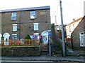
- Clicking on the map will re-center to the selected point.
- The higher the marker number, the further away the image location is from the centre of the postcode.
Image Listing (230 Images Found)
Images are licensed for reuse under creativecommons.org/licenses/by-sa/2.0
Image
Details
Distance
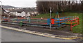
1
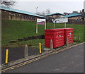
Recycling bank, Dan-y-Bryn Road, Treforest
The yellow metal posts show NO PARKING.
Image: © Jaggery
Taken: 30 Jan 2014
0.01 miles
2
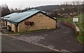
Entrance to White Tips Stadium, Treforest
The entrance from Dan-y-Bryn Road past the clubhouse
is into the home ground of Treforest Football Club.
Image: © Jaggery
Taken: 30 Jan 2014
0.01 miles
3
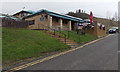
Steps up to Treforest Football Club
The clubhouse is at the NE edge of the club's ground at White Tips Stadium, Dan-y-Bryn Road.
Image: © Jaggery
Taken: 30 Jan 2014
0.02 miles
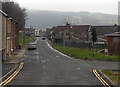
4
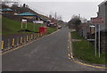
Dan-y-Bryn Road, Treforest
Viewed from Kingsland Terrace. Arrows on brown signs on the right point towards
a football club and a community centre. This is also the way to Dan-y-Bryn Farm.
Image: © Jaggery
Taken: 30 Jan 2014
0.03 miles
5
Children's play area in Treforest
On the corner of Kingsland Terrace and Duke Street.
Image: © Jaggery
Taken: 30 Jan 2014
0.04 miles
6
King Street electricity substation in Treforest
The identifier on the Western Power Distribution substation shows King Street Treforest S/S 541736, though it is located alongside Duke Street, a few metres from the corner of King Street.
Image: © Jaggery
Taken: 30 Jan 2014
0.04 miles
7
Duke Street, Treforest
Viewed from the edge of Birchley Close looking NE past the right turn for Park Close.
Image: © Jaggery
Taken: 30 Jan 2014
0.05 miles
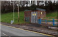
8
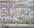
Ordnance Survey Cut Mark
This OS cut mark can be found on No83 King Street. It marks a point 78.992m above mean sea level.
Image: © Adrian Dust
Taken: 23 Jun 2018
0.05 miles
9
Former Oddfellows Hall, Treforest
The house on the corner of Bridge Street and Old Park Terrace bears the stone inscription ODDFELLOWS HALL BUILT A.D. 1848.
Image: © Jaggery
Taken: 9 Dec 2011
0.05 miles
10
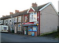
Vinnys Supermarket, Treforest
Formerly a Spar store, Vinnys may not be many people's idea of a supermarket!
Located on Queen Street at the Y-junction with Princess Street and New Park Crescent.
Image: © Jaggery
Taken: 9 Dec 2011
0.05 miles