IMAGES TAKEN NEAR TO
Ruperra Close, CARDIFF, CF3 6HX
Introduction
This page details the photographs taken nearby to Ruperra Close, CF3 6HX by members of the Geograph project.
The Geograph project started in 2005 with the aim of publishing, organising and preserving representative images for every square kilometre of Great Britain, Ireland and the Isle of Man.

There are currently over 7.5m images from over14,400 individuals and you can help contribute to the project by visiting https://www.geograph.org.uk
Image Map
Images are licensed for reuse under creativecommons.org/licenses/by-sa/2.0
Notes
- Clicking on the map will re-center to the selected point.
- The higher the marker number, the further away the image location is from the centre of the postcode.
Image Listing (37 Images Found)
Images are licensed for reuse under creativecommons.org/licenses/by-sa/2.0
Image
Details
Distance
1
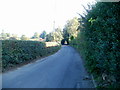
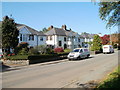
Old St Mellons : Bridge Road climbs towards residential area
Viewed from near the corner of Ruperra Close. http://www.geograph.org.uk/photo/2109030 Bridge Road (B4562) climbs towards houses at the western edge of Old St Mellons.
Image: © Jaggery
Taken: 11 Oct 2010
0.02 miles
2
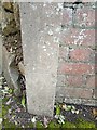
Benchmark, Old St Mellons,
An unusual benchmark on a concrete post in the entrance to Ty'r Bont, Bridge Road, Old St Mellons. Unusual in that it only has two downward cuts.
Image: © Father Ted
Taken: 19 Jul 2020
0.07 miles
4
Ruperra Close, Old St Mellons
Ruperra Close heads away from the south side of Bridge Road towards houses (out of shot beyond the bend).
Image: © Jaggery
Taken: 11 Oct 2010
0.08 miles
5
Old St Mellons : Tyr Winch houses opposite a playing field
Houses on the west side of the road, opposite a community playing field. http://www.geograph.org.uk/photo/2107360
Image: © Jaggery
Taken: 11 Oct 2010
0.11 miles
6
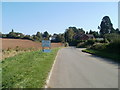
Welcome to Old St Mellons
Bridge Road (B4562) heading SE approaches the boundary of Old St Mellons.
Image: © Jaggery
Taken: 11 Oct 2010
0.11 miles
7
Westernmost houses, Old St Mellons
Bridge Road houses at the western edge of Old St Mellons.
Image: © Jaggery
Taken: 11 Oct 2010
0.11 miles
8
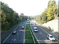
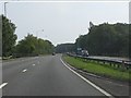
Eastern Avenue, Cardiff
Eastern Avenue (A48) heading west, viewed from the Tyr Winch Road bridge.
Image: © Jaggery
Taken: 11 Oct 2010
0.12 miles
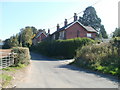
9

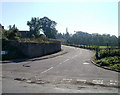
Bridge Road, Old St Mellons
Bridge Road heads away from Tyr Winch Road towards an arch-like bower of overhanging vegetation.
Image: © Jaggery
Taken: 11 Oct 2010
0.12 miles
10

Signpost opposite Bridge Road, Old St Mellons
The signpost indicates Cefn Mably and Michaelstone-y-Vedw to the left, St Mellons and Cardiff to the right, and Llanedeyrn facing the camera. Michaelstone-y-Vedw is now usually spelt Michaelston-y-Fedw. The road opposite the camera is the entrance to the residence Croesllechfaen.
Image: © Jaggery
Taken: 11 Oct 2010
0.12 miles