IMAGES TAKEN NEAR TO
Beach Road, PORTHCAWL, CF36 5NH
Introduction
This page details the photographs taken nearby to Beach Road, CF36 5NH by members of the Geograph project.
The Geograph project started in 2005 with the aim of publishing, organising and preserving representative images for every square kilometre of Great Britain, Ireland and the Isle of Man.

There are currently over 7.5m images from over14,400 individuals and you can help contribute to the project by visiting https://www.geograph.org.uk
Image Map
Images are licensed for reuse under creativecommons.org/licenses/by-sa/2.0
Notes
- Clicking on the map will re-center to the selected point.
- The higher the marker number, the further away the image location is from the centre of the postcode.
Image Listing (146 Images Found)
Images are licensed for reuse under creativecommons.org/licenses/by-sa/2.0
Image
Details
Distance
1
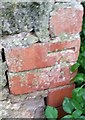
Ordnance Survey Cut Mark
This OS cut mark can be found on the wall of No15 Beach Road. It marks a point 6.980m above mean sea level.
Image: © Adrian Dust
Taken: 23 Oct 2017
0.03 miles
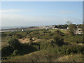
2
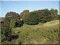
Trees at the western boundary of Newton Burrows
The western end of an area of duneland which extends over Newton Burrows and Merthyr Mawr Warren to the Ogmore River.
Image: © eswales
Taken: 25 Sep 2015
0.03 miles
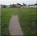
3
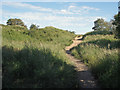
Footpath in Newton duneland
A footpath in the west of Newton Burrows heads towards the coast.
Image: © eswales
Taken: 13 Jun 2014
0.05 miles
4

Four flags
Mixed allegiances. Perhaps the owner is a member of the Pirates Club, Porthcawl.
Image: © Alan Hughes
Taken: 3 Feb 2021
0.08 miles
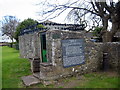
6
Sandford's Well
The well, dedicated to St John the Baptist, is just down Beach Road from the Church of St John. There is no access to the well, the door is barred and barbed round the top. On the west wall of the building is a poem written about the well in 1607. Image
Image: © Eirian Evans
Taken: 25 May 2021
0.09 miles
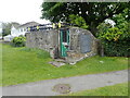
7
Sandford's Well
Information and poem about Sandord'w Well Image
Image: © Eirian Evans
Taken: 25 May 2021
0.09 miles
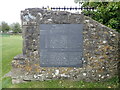
8
Ffynnon Sanford / Sanford's Well
Mae lefel dwr y ffynnon yn cael ei heffeithio gan lanw'r mor cyfagos. Ysgrifennwyd cerdd amdani yn 1606.
The water level of the well is influenced by the tides. A poem was written about the well in 1606.
Image: © Alan Richards
Taken: 10 Apr 2005
0.10 miles
9
Towards Mayfield Avenue, Porthcawl
From Church Street towards Beach Road and houses in Mayfield Avenue.
Image: © Jaggery
Taken: 29 Mar 2016
0.10 miles
10
The south west corner of Newton Burrows
The start of a large area of dunes, comprising Newton Burrows and Merthyr Mawr Warren, which extends eastwards to the Ogmore River.
Image: © eswales
Taken: 25 Sep 2015
0.11 miles