IMAGES TAKEN NEAR TO
Maple Walk, PORTHCAWL, CF36 5AY
Introduction
This page details the photographs taken nearby to Maple Walk, CF36 5AY by members of the Geograph project.
The Geograph project started in 2005 with the aim of publishing, organising and preserving representative images for every square kilometre of Great Britain, Ireland and the Isle of Man.

There are currently over 7.5m images from over14,400 individuals and you can help contribute to the project by visiting https://www.geograph.org.uk
Image Map
Images are licensed for reuse under creativecommons.org/licenses/by-sa/2.0
Notes
- Clicking on the map will re-center to the selected point.
- The higher the marker number, the further away the image location is from the centre of the postcode.
Image Listing (105 Images Found)
Images are licensed for reuse under creativecommons.org/licenses/by-sa/2.0
Image
Details
Distance
1

Fairy door, Newton Burrows
Christmassy tree attachment at Newton Burrows.
Image: © eswales
Taken: 16 Apr 2021
0.06 miles
2

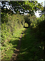
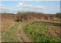
Footpath to Wig Fach, Newton Burrows (2)
The path running between a dense, brambly hedge and a thick bank of bracken in September 2015.
Image: © eswales
Taken: 25 Sep 2015
0.06 miles
3
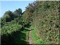
Footpath to Wig Fach, Newton Burrows
The path seen in September 2015, with thick vegetation close by on both sides.
Image: © eswales
Taken: 25 Sep 2015
0.07 miles
4
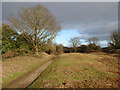
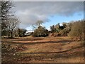
Path to Wig Fach in cleared area at Newton Burrows
Quite a change from how this area appeared in September 2015, as seen in some of the other pictures submitted for this grid square. Not only is the land just to the south of the path largely free of bracken, the dense hedgerow which lay on its north side seems to have been removed.
See Image] and Image] and Image
Image: © eswales
Taken: 10 Feb 2021
0.07 miles
5
Footpath to Wig Fach at Newton Burrows
A public footpath which some have sought to be upgraded to a bridleway - see http://www.bridgend-today.co.uk/article.cfm?id=125776&headline=D_Day%20tomorrow%20on%20Newton%20footpath%20dispute§ionIs=news&searchyear=2019 for example.
Image: © eswales
Taken: 10 Feb 2021
0.08 miles
6
Footpath from Wig Fach, Newton Burrows
The path running alongside an area overgrown with bracken in September 2015.
Image: © eswales
Taken: 25 Sep 2015
0.08 miles
7
Public footpath in duneland near Newton
A footpath on the Newton to Candleston Circular Walk. One of the considerable number of waymark posts on this walk is seen in the photograph.
Image: © eswales
Taken: 19 Apr 2013
0.08 miles
8
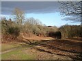
Cleared area at Newton Burrows
Area of duneland immediately to the south of Danygraig which has been cleared of bracken and other vegetation.
Image: © eswales
Taken: 10 Feb 2021
0.08 miles
9
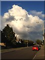
Storm clouds in Porthcawl
Storm clouds over Danygraig Avenue, Porthcawl.
Image: © Alan Hughes
Taken: 3 Aug 2013
0.08 miles
10

Waiting patiently
No workmen, no cars, no people .... no point!
Image: © Alan Hughes
Taken: 5 Apr 2021
0.09 miles