IMAGES TAKEN NEAR TO
St. Brides Close, PORTHCAWL, CF36 3NR
Introduction
This page details the photographs taken nearby to St. Brides Close, CF36 3NR by members of the Geograph project.
The Geograph project started in 2005 with the aim of publishing, organising and preserving representative images for every square kilometre of Great Britain, Ireland and the Isle of Man.

There are currently over 7.5m images from over14,400 individuals and you can help contribute to the project by visiting https://www.geograph.org.uk
Image Map
Images are licensed for reuse under creativecommons.org/licenses/by-sa/2.0
Notes
- Clicking on the map will re-center to the selected point.
- The higher the marker number, the further away the image location is from the centre of the postcode.
Image Listing (71 Images Found)
Images are licensed for reuse under creativecommons.org/licenses/by-sa/2.0
Image
Details
Distance
1
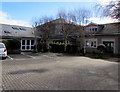
St David's Church, Nottage
Set back from the south side of Florence Street, St David's Church is part of the Church in Wales Diocese of Llandaff.
The church's website states that St David's Church in Nottage came into existence in 1948. Previously, Communion Services had been held in a house named Redlands in West Road. However, soon after the end of the Second World War steps were taken to have a church built in Nottage. A small wooden church was erected in 1948 on land given by Mr J. K. Blundell. The building was an ex-Church Army hut that had been purchased from an RAF camp. The site had been used by the American Forces during the war. Two Nissen huts that they had left were also acquired. These were used as a schoolroom and anteroom. The small mission church was dedicated to St David and consecrated by the Bishop of Llandaff on March 24th 1948.
By 1967, the life of the Nissen huts had come to an end. In 1968 they were demolished and a classroom-style timber church hall was built. In 1970 part of the original site was sold for housing (now The Glade) and in 1978 the car park and stone boundary walls were constructed.
By 1991, in order to cater for the growing community in Nottage it was decided to build a new church on the existing site. Building work on Stage 1 began on January 8th 1992. Money was raised from grants, donations and fundraising. The work began with the demolition of the old church. While the building work was taking place all services were held in the hall. It was a nostalgic and sad time for many people but the old bell was saved and reinstalled in the new church. The church (Stage 1) was completed on November 6th 1992 and consecrated by Roy, Bishop of Llandaff on November 12th. The hall work (Stage 2) was started on December 12th 1994. All building work completed in May 1995.
Image: © Jaggery
Taken: 4 Mar 2017
0.03 miles
2
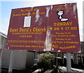
Information board outside St David's Church, Nottage
Facing Florence Street on the north side of this http://www.geograph.org.uk/photo/5300824 church.
Image: © Jaggery
Taken: 4 Mar 2017
0.04 miles
3
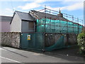
West Road demolition site, Nottage, Porthcawl
A fenced-off derelict building is being demolished in early March 2017.
Image: © Jaggery
Taken: 4 Mar 2017
0.05 miles
4
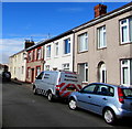
Florence Street houses, Nottage
The houses on the right are opposite St David's Church. http://www.geograph.org.uk/photo/5300824
Image: © Jaggery
Taken: 4 Mar 2017
0.05 miles
5
Nottage Stores, Nottage
Village shop on the corner of Heol-y-Capel and Ty Canol.
Image: © Jaggery
Taken: 4 Mar 2017
0.06 miles
6

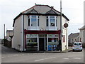
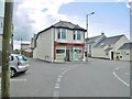
Curly Tops and ECigg Lifestyle, Nottage
Curly Tops hair stylist is at 1 Heol-y-Capel.
ECigg Lifestyle (electronic cigarettes, accessories & e-liquids) is at 2 Heol-y-Capel.
Image: © Jaggery
Taken: 4 Mar 2017
0.06 miles
7
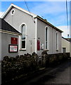
Nottage General Baptist & Unitarian Chapel, Nottage
This is the c1840 rebuild of the original chapel built in the late 18th century.
Now the chapel's hall, the building on the left http://www.geograph.org.uk/photo/5300632 was originally a school room.
Image: © Jaggery
Taken: 4 Mar 2017
0.06 miles
9
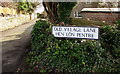
Old Village Lane/Hen L?n Pentre name sign, Nottage, Porthcawl
The English/Welsh name sign faces West Road.
Image: © Jaggery
Taken: 4 Mar 2017
0.06 miles
10
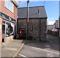
King George V pillarbox on a Nottage corner
The pillarbox is on the right here http://www.geograph.org.uk/photo/5300738 outside 2 Heol-y-Capel which in March 2017 is occupied by ECigg Lifestyle. The presence of a pillarbox suggests that 2 Heol-y-Capel may once have been the village post office.
Image: © Jaggery
Taken: 4 Mar 2017
0.06 miles