IMAGES TAKEN NEAR TO
Tythegston Close, PORTHCAWL, CF36 3HJ
Introduction
This page details the photographs taken nearby to Tythegston Close, CF36 3HJ by members of the Geograph project.
The Geograph project started in 2005 with the aim of publishing, organising and preserving representative images for every square kilometre of Great Britain, Ireland and the Isle of Man.

There are currently over 7.5m images from over14,400 individuals and you can help contribute to the project by visiting https://www.geograph.org.uk
Image Map
Images are licensed for reuse under creativecommons.org/licenses/by-sa/2.0
Notes
- Clicking on the map will re-center to the selected point.
- The higher the marker number, the further away the image location is from the centre of the postcode.
Image Listing (32 Images Found)
Images are licensed for reuse under creativecommons.org/licenses/by-sa/2.0
Image
Details
Distance
1
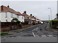
Westfield Crescent, Nottage, Porthcawl
Viewed across West Road. The sign on the left http://www.geograph.org.uk/photo/5320377 shows that Westfield Crescent leads to Greenfield Way and Connaught Close.
Image: © Jaggery
Taken: 16 Mar 2017
0.15 miles
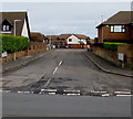
2
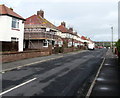
Westfield Crescent, Nottage, Porthcawl
From West Road, Westfield Crescent leads to Greenfield Way and Connaught Close.
Image: © Jaggery
Taken: 16 Mar 2017
0.15 miles
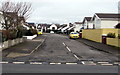
3
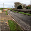
Nottage Mead, Nottage, Porthcawl
Long cul-de-sac on the northeast side of West Road.
Image: © Jaggery
Taken: 16 Mar 2017
0.16 miles
4
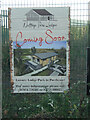
Nottage Park Lodges notice beside Moor Lane
Notice on fence at a site where a lodge park is going to be established. See Image
Image: © eswales
Taken: 4 Nov 2021
0.19 miles
5
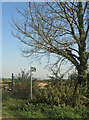
The start of a public footpath on Moor Lane, near Nottage
A sign and tree at the southern end of a public footpath which runs across the course of the Grove Golf Club to a point on the A 4229 near South Cornelly and the Grove clubhouse.
Image: © eswales
Taken: 9 Sep 2014
0.19 miles
6
Nottage Meadows, Nottage, Porthcawl
On the northeast side of West Road, Nottage Meadows leads to several residential cul-de-sacs. http://www.geograph.org.uk/photo/5319968
Image: © Jaggery
Taken: 16 Mar 2017
0.20 miles
7
The Retreat, Nottage, Porthcawl
The Retreat (Yr Encilfa in Welsh) is a cul-de-sac on the northeast side of West Road.
Image: © Jaggery
Taken: 16 Mar 2017
0.20 miles
8
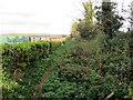
Llwybr ger Pwll y Moor / Path near Pwll y Moor
Llwybr cyhoeddus ger Pwll y Moor yn mynd tuag at yr A4229.
A public footpath near Pwll y Moor (trans. moor pool) heads in the direction of the A4229.
Image: © Alan Richards
Taken: 29 Oct 2023
0.20 miles
9
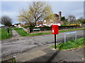
Queen Elizabeth II postbox on a Nottage corner, Porthcawl
On the corner of West Road and Nottage Mead.
Image: © Jaggery
Taken: 16 Mar 2017
0.21 miles
10
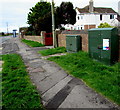
Two telecoms cabinets, West Road, Nottage, Porthcawl
BT cabinet on the right, Virgin Media cabinet on the left.
Image: © Jaggery
Taken: 16 Mar 2017
0.21 miles