1
Ordnance Survey Cut Mark
This OS cut mark can be found on the east face of the school. It marks a point 100.810m above mean sea level.
Image: © Adrian Dust
Taken: 28 Apr 2018
0.01 miles
2
Primary school in Heol-y-cyw
Viewed across High Street. This is the Heol-y-cyw site of Pencoed Primary School. http://www.geograph.org.uk/photo/4240947
Image: © Jaggery
Taken: 14 Nov 2014
0.02 miles
3
Primary school reception entrance, Heol-y-cyw
Viewed from the west side of High Street. On the left, an oval inscription on the wall shows the year 1911 and the spelling HEOLYCYW (no spaces or hyphens). Though the name on the right is HEOL-Y-CYW PRIMARY SCHOOL, this site is now part of Pencoed Primary School. The main school buildings are in Pencoed about 3km away. http://www.geograph.org.uk/photo/4240947
Image: © Jaggery
Taken: 14 Nov 2014
0.02 miles
4
Ordnance Survey Cut Mark
This OS cut mark can be found on the school wall. It marks a point 99.170m above mean sea level.
Image: © Adrian Dust
Taken: 28 Apr 2018
0.02 miles
5
High Street, Heol-y-Cyw
Image: © Colin Pyle
Taken: 9 Dec 2012
0.03 miles
6
Heol-y-Cyw
View of the High Street, looking northwards.
Image: © Ian Paterson
Taken: 2 Jun 2008
0.03 miles
7
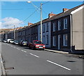
Long row of houses in High Street, Heol-y-cyw
On the east side of High Street.
Image: © Jaggery
Taken: 14 Nov 2014
0.03 miles
8
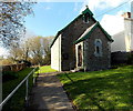
St Paul's Church, Heol-y-cyw
Church in Wales church on the west side of High Street. The foundation stone shows the year 1889.
Image: © Jaggery
Taken: 14 Nov 2014
0.04 miles
9
Bethel Newydd Chapel, Heol-y-cyw
The first chapel in the village, Bethel Hen, was built in 1820. In 1906 it was replaced by the larger chapel seen here, Bethel Newydd, on the west side of High Street. No denomination was shown on the chapel nameboard at the November 2014 date of this view.
Image: © Jaggery
Taken: 14 Nov 2014
0.04 miles
10
St.Paul's Church, Heol-y-Cyw
Built for £300 in 1889, St.Paul's Church, Heol-y-Cyw.
Image: © Alan Hughes
Taken: 15 Apr 2016
0.04 miles


