IMAGES TAKEN NEAR TO
Ballarat, BRIDGEND, CF35 6LY
Introduction
This page details the photographs taken nearby to Ballarat, CF35 6LY by members of the Geograph project.
The Geograph project started in 2005 with the aim of publishing, organising and preserving representative images for every square kilometre of Great Britain, Ireland and the Isle of Man.

There are currently over 7.5m images from over14,400 individuals and you can help contribute to the project by visiting https://www.geograph.org.uk
Image Map
Images are licensed for reuse under creativecommons.org/licenses/by-sa/2.0
Notes
- Clicking on the map will re-center to the selected point.
- The higher the marker number, the further away the image location is from the centre of the postcode.
Image Listing (26 Images Found)
Images are licensed for reuse under creativecommons.org/licenses/by-sa/2.0
Image
Details
Distance
1
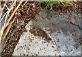
Ordnance Survey Rivet
This OS rivet can be found on a rock 10m south of the track. It marks a point 96.576m above mean sea level.
Image: © Adrian Dust
Taken: 28 Apr 2018
0.10 miles
2
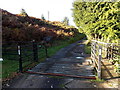
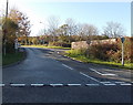
Side arm of Penprysg Road, Pencoed
No longer a through route, this NW arm of Penprysg Road used to be the route to and from
the B4280 junction. It became a side arm after the main course of Penprysg Road was realigned to create a T junction http://www.geograph.org.uk/photo/4248495 with the B4280.
Image: © Jaggery
Taken: 14 Nov 2014
0.13 miles
3
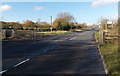
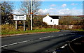
Grid across the B4280 near Pencoed
The road heads WNW away from Pencoed. Ahead, it passes through Hirwaun Common.
Image: © Jaggery
Taken: 14 Nov 2014
0.14 miles
4
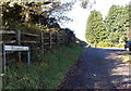
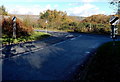
Grid across Ballarat, Pencoed
Viewed from the Penprysg Road end along Ballarat, a road to Hirwaun Common.
The grid and gates prevent hoofed animals on the common land entering Penprysg Road.
Image: © Jaggery
Taken: 14 Nov 2014
0.14 miles
5
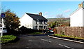
Northern end of Penprysg Road, Pencoed
Penprysg Road heads south into Pencoed, away from the B4280.
Image: © Jaggery
Taken: 14 Nov 2014
0.14 miles
6
Ballarat, Pencoed
Side road to common land NW of Penprysg Road.
Image: © Jaggery
Taken: 14 Nov 2014
0.15 miles
7
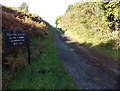
Motorcycling on the common is prohibited by law, Pencoed
The notice is alongside Ballarat at an eastern entrance to Hirwaun Common.
Image: © Jaggery
Taken: 14 Nov 2014
0.15 miles
8
T-junction ahead, Pencoed
Penprysg Road approaches its northern end at the B4280 junction.
Left at the junction for Bryncethin or right for Llantrisant.
Image: © Jaggery
Taken: 14 Nov 2014
0.15 miles
9
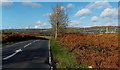
Brown bracken and green grass NW of Pencoed
November 2014 colours alongside the B4280.
Image: © Jaggery
Taken: 14 Nov 2014
0.15 miles
10
End of the 30 zone at the northern edge of Pencoed
The 30mph speed limit along Penprysg Road increases to the National Speed Limit on the B4280.
Image: © Jaggery
Taken: 14 Nov 2014
0.16 miles