IMAGES TAKEN NEAR TO
Pen Yr Ysgol, MAESTEG, CF34 9YE
Introduction
This page details the photographs taken nearby to Pen Yr Ysgol, CF34 9YE by members of the Geograph project.
The Geograph project started in 2005 with the aim of publishing, organising and preserving representative images for every square kilometre of Great Britain, Ireland and the Isle of Man.

There are currently over 7.5m images from over14,400 individuals and you can help contribute to the project by visiting https://www.geograph.org.uk
Image Map
Images are licensed for reuse under creativecommons.org/licenses/by-sa/2.0
Notes
- Clicking on the map will re-center to the selected point.
- The higher the marker number, the further away the image location is from the centre of the postcode.
Image Listing (13 Images Found)
Images are licensed for reuse under creativecommons.org/licenses/by-sa/2.0
Image
Details
Distance
1
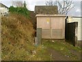
Electricity sub station, St Cynwyd's Avenue, Maesteg
Image: © Alex McGregor
Taken: 27 Jan 2012
0.17 miles
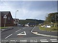
2
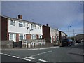
Brynteg, at the junction with Keir Hardie Rd, Maesteg
Image: © John Lord
Taken: 10 Oct 2008
0.18 miles

4
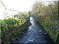
River Llynfi flows away from Meadow Street footbridge, Maesteg
Viewed from the footbridge http://www.geograph.org.uk/photo/4229075 connecting the southern end of Meadow Street with Commercial Street.
The Llynfi is a tributary of the River Ogmore, into which it flows at Aberkenfig.
Image: © Jaggery
Taken: 17 Nov 2011
0.21 miles
5
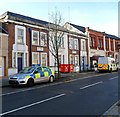
Maesteg Police Station
A police car and police van are parked outside the Commercial Street police station, part of the South Wales Police force. The inscription in stone on the building is COUNTY POLICE STATION 1938.
Image: © Jaggery
Taken: 17 Nov 2011
0.21 miles
6
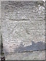
Ordnance Survey Cut Mark
This OS cut mark can be found on the wall post of St Michael & All Angels Church. It marks a point 146.664m above mean sea level.
Image: © Adrian Dust
Taken: 9 Mar 2016
0.21 miles
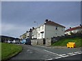
7
Cwrt Llynfi, Maesteg
A new development off Keir Hardie Rd
Image: © John Lord
Taken: 10 Oct 2008
0.21 miles
8
The Royal British Legion, Maesteg
Located in Commercial Street.
Founded as the British Legion in 1921, the charity was granted a Royal Charter in May 1971 to mark its fiftieth anniversary. This gave the Legion the privilege of the prefix Royal. The charity gives financial, social and emotional support to those who have served, or are currently serving, in the British Armed Forces, and their dependants.
Image: © Jaggery
Taken: 17 Nov 2011
0.22 miles
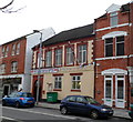
9

The Prince of Wales, Maesteg
The pub at 119 Commercial Street is flanked on the right by a fish & chip shop, A Chip Off The Old Block and on the left by the Momtaj licensed Indian restaurant, with a takeaway service available.
Image: © Jaggery
Taken: 17 Nov 2011
0.22 miles
10
Heol Pentre, junction with Keir Hardie Rd, Maesteg
Image: © John Lord
Taken: 10 Oct 2008
0.22 miles