IMAGES TAKEN NEAR TO
Zoar Avenue, MAESTEG, CF34 9UT
Introduction
This page details the photographs taken nearby to Zoar Avenue, CF34 9UT by members of the Geograph project.
The Geograph project started in 2005 with the aim of publishing, organising and preserving representative images for every square kilometre of Great Britain, Ireland and the Isle of Man.

There are currently over 7.5m images from over14,400 individuals and you can help contribute to the project by visiting https://www.geograph.org.uk
Image Map (Loading...)


Getting Data...Please wait
Leaflet Map data © OpenStreetMap
Images are licensed for reuse under creativecommons.org/licenses/by-sa/2.0
Notes
- Clicking on the map will re-center to the selected point.
- The higher the marker number, the further away the image location is from the centre of the postcode.
Image Listing (185 Images Found)
Images are licensed for reuse under creativecommons.org/licenses/by-sa/2.0
Image
Details
Distance
1
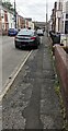
Patched pavement, Zoar Avenue, Maesteg
Viewed in June 2024.
Image: © Jaggery
Taken: 12 Jun 2024
0.02 miles
2
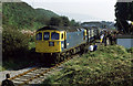
Maesteg Castle Street Station
Class 33, 33019 stands in the closed (1970) Maesteg Castle Street station with the Welsh Washery Wanderer railtour. The line fell into disuse following the closure of the pits it served in 1985. A new station was built about a quarter of a mile to the southeast of here in 1992 as British Rail reintroduced passenger services to the line. The track has since been removed beyond that station though the old platform is still here hidden in the undergrowth and the footbridge remains in place as a reminder that there was once a station here.
Image: © Martin Addison
Taken: 28 Sep 1985
0.03 miles
3

St John Ambulance hall, Maesteg
Located on the corner of Zoar Place and Zoar Avenue, alongside Zoar Chapel of Rest. http://www.geograph.org.uk/photo/4227337
An inscription in stone above the doorway shows MAESTEG CENTRAL DIVISION 1955.
Text on the door shows the times that the Badgers, Cadets and Adults groups meet here.
Image: © Jaggery
Taken: 30 Oct 2014
0.03 miles
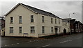
4
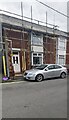
Zoar Avenue house under scaffolding, Maesteg
In June 2024.
Image: © Jaggery
Taken: 12 Jun 2024
0.03 miles
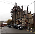
5
Masonic Temple and Maesteg College, Maesteg
Viewed across Castle Street. Masonic Temple on the left, Maesteg College on the right.
Among distances shown on the large road sign are 9 miles to Bridgend and 7 to Port Talbot.
Image: © Jaggery
Taken: 30 Oct 2014
0.03 miles
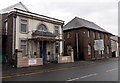
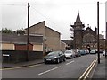
6
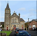
Grade II listed Zoar, Maesteg
Located on the corner of Zoar Place and Zoar Avenue.
The first Zoar Independent Chapel was built here in 1842 and rebuilt in 1874. The present chapel is a 1911 rebuild, designed by architect William Beddoe Rees of Cardiff, in the Gothic style.
After Zoar closed in 1978 it was converted for use as a chapel of rest. Grade II listed in July 1997.
A St John Ambulance hall is on the right. http://www.geograph.org.uk/photo/3005914
Image: © Jaggery
Taken: 17 Nov 2011
0.03 miles
7
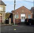
St John Ambulance hall, Maesteg
Located on the corner of Zoar Place and Zoar Avenue, alongside Zoar Chapel of Rest. http://www.geograph.org.uk/photo/3005808
An inscription in stone above the doorway shows MAESTEG CENTRAL DIVISION 1955.
Image: © Jaggery
Taken: 17 Nov 2011
0.03 miles
8
Corner of Zoar Place and Castle Street, Maesteg
The Zoar Place name sign is on the left.
Image: © Jaggery
Taken: 30 Oct 2014
0.04 miles
9
Zoar Chapel of Rest, Maesteg
The building on the corner of Zoar Avenue and Zoar Place used to be Zoar Independent Chapel.
After the chapel closed in 1978, it was converted for use as a chapel of rest.
Image: © Jaggery
Taken: 30 Oct 2014
0.04 miles
10
Zoar Place, Maesteg
Viewed from Castle Street looking along Zoar Place towards Zoar Chapel of Rest. http://www.geograph.org.uk/photo/4227337
Image: © Jaggery
Taken: 30 Oct 2014
0.04 miles