IMAGES TAKEN NEAR TO
Oakwood, MAESTEG, CF34 9UD
Introduction
This page details the photographs taken nearby to Oakwood, CF34 9UD by members of the Geograph project.
The Geograph project started in 2005 with the aim of publishing, organising and preserving representative images for every square kilometre of Great Britain, Ireland and the Isle of Man.

There are currently over 7.5m images from over14,400 individuals and you can help contribute to the project by visiting https://www.geograph.org.uk
Image Map
Images are licensed for reuse under creativecommons.org/licenses/by-sa/2.0
Notes
- Clicking on the map will re-center to the selected point.
- The higher the marker number, the further away the image location is from the centre of the postcode.
Image Listing (52 Images Found)
Images are licensed for reuse under creativecommons.org/licenses/by-sa/2.0
Image
Details
Distance
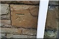
1
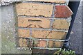
Ordnance Survey Cut Mark
This OS cut mark can be found on No36 Llwydarth Road. It marks a point 120.030m above mean sea level.
Image: © Adrian Dust
Taken: 11 Nov 2020
0.07 miles
2
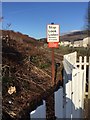
Railway Warning Notice
Warning sign near the Maesteg railway.
Image: © Alan Hughes
Taken: 19 Jan 2017
0.08 miles
4
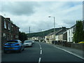
Park View, Maesteg
Park View descends from the east side of the A4063 Llwydarth Road.
Image: © Jaggery
Taken: 24 Feb 2017
0.14 miles
6
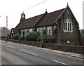
St Mary the Virgin church, Troedrhiwgarth, Maesteg
Part of the Church in Wales Diocese of Llandaff, viewed across the B4282 Bridgend Road.
Image: © Jaggery
Taken: 17 Feb 2017
0.17 miles
7
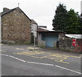
Bus stop, shelter and postbox in a wall, Garth, Maesteg
Alongside the B4282 Bridgend Road.
Image: © Jaggery
Taken: 17 Feb 2017
0.18 miles
8
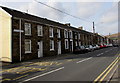
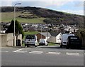
Long row of houses, Garth, Maesteg
Extending for about 100 metres along the west side of the B4282 Bridgend Road.
Image: © Jaggery
Taken: 27 Feb 2015
0.18 miles
9
Ordnance Survey Cut Mark
This OS cut mark can be found on No165 Bridgend Road. It marks a point 110.783m above mean sea level.
Image: © Adrian Dust
Taken: 11 Nov 2020
0.18 miles
10
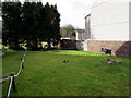
Garden of Remembrance, Garth, Maesteg
On the north side of this http://www.geograph.org.uk/photo/4364153 church.
Image: © Jaggery
Taken: 27 Feb 2015
0.18 miles