IMAGES TAKEN NEAR TO
Fairfield Avenue, MAESTEG, CF34 9LW
Introduction
This page details the photographs taken nearby to Fairfield Avenue, CF34 9LW by members of the Geograph project.
The Geograph project started in 2005 with the aim of publishing, organising and preserving representative images for every square kilometre of Great Britain, Ireland and the Isle of Man.

There are currently over 7.5m images from over14,400 individuals and you can help contribute to the project by visiting https://www.geograph.org.uk
Image Map
Images are licensed for reuse under creativecommons.org/licenses/by-sa/2.0
Notes
- Clicking on the map will re-center to the selected point.
- The higher the marker number, the further away the image location is from the centre of the postcode.
Image Listing (8 Images Found)
Images are licensed for reuse under creativecommons.org/licenses/by-sa/2.0
Image
Details
Distance
1
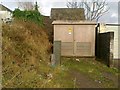
Electricity sub station, St Cynwyd's Avenue, Maesteg
Image: © Alex McGregor
Taken: 27 Jan 2012
0.09 miles
2
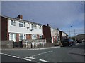
Brynteg, at the junction with Keir Hardie Rd, Maesteg
Image: © John Lord
Taken: 10 Oct 2008
0.15 miles
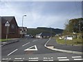
3
Heol Pentre, junction with Keir Hardie Rd, Maesteg
Image: © John Lord
Taken: 10 Oct 2008
0.18 miles
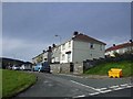
4
Cwrt Llynfi, Maesteg
A new development off Keir Hardie Rd
Image: © John Lord
Taken: 10 Oct 2008
0.21 miles
5
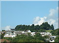
Maesteg (south)
looking North at housing at the South end of Maesteg high above the valley.
Image: © Chris Shaw
Taken: Unknown
0.23 miles
6
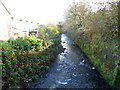
River Llynfi flows away from Meadow Street footbridge, Maesteg
Viewed from the footbridge http://www.geograph.org.uk/photo/4229075 connecting the southern end of Meadow Street with Commercial Street.
The Llynfi is a tributary of the River Ogmore, into which it flows at Aberkenfig.
Image: © Jaggery
Taken: 17 Nov 2011
0.24 miles
7
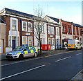
Maesteg Police Station
A police car and police van are parked outside the Commercial Street police station, part of the South Wales Police force. The inscription in stone on the building is COUNTY POLICE STATION 1938.
Image: © Jaggery
Taken: 17 Nov 2011
0.24 miles
8
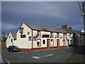
The Red Cow, corner of Alma Rd and Bryn Celyn, Maesteg
Image: © John Lord
Taken: 10 Oct 2008
0.24 miles