IMAGES TAKEN NEAR TO
Bryn Celyn, MAESTEG, CF34 9LS
Introduction
This page details the photographs taken nearby to Bryn Celyn, CF34 9LS by members of the Geograph project.
The Geograph project started in 2005 with the aim of publishing, organising and preserving representative images for every square kilometre of Great Britain, Ireland and the Isle of Man.

There are currently over 7.5m images from over14,400 individuals and you can help contribute to the project by visiting https://www.geograph.org.uk
Image Map
Images are licensed for reuse under creativecommons.org/licenses/by-sa/2.0
Notes
- Clicking on the map will re-center to the selected point.
- The higher the marker number, the further away the image location is from the centre of the postcode.
Image Listing (4 Images Found)
Images are licensed for reuse under creativecommons.org/licenses/by-sa/2.0
Image
Details
Distance
1
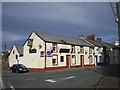
The Red Cow, corner of Alma Rd and Bryn Celyn, Maesteg
Image: © John Lord
Taken: 10 Oct 2008
0.07 miles
2
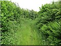
Llwybr cyhoeddus Maesteg public footpath
Llwybr cyhoeddus yn arwain at Ffarm Llwydarth, Maesteg
Public footpath leading to Llwydarth Farm, Maesteg
Image: © Alan Richards
Taken: 17 Jun 2012
0.17 miles
3
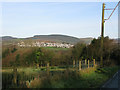
View across the valley from the Llan Road
Image: © Nick Smith
Taken: 13 Jan 2012
0.19 miles
4
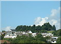
Maesteg (south)
looking North at housing at the South end of Maesteg high above the valley.
Image: © Chris Shaw
Taken: Unknown
0.20 miles