IMAGES TAKEN NEAR TO
Llwydarth Road, MAESTEG, CF34 9EU
Introduction
This page details the photographs taken nearby to Llwydarth Road, CF34 9EU by members of the Geograph project.
The Geograph project started in 2005 with the aim of publishing, organising and preserving representative images for every square kilometre of Great Britain, Ireland and the Isle of Man.

There are currently over 7.5m images from over14,400 individuals and you can help contribute to the project by visiting https://www.geograph.org.uk
Image Map
Images are licensed for reuse under creativecommons.org/licenses/by-sa/2.0
Notes
- Clicking on the map will re-center to the selected point.
- The higher the marker number, the further away the image location is from the centre of the postcode.
Image Listing (24 Images Found)
Images are licensed for reuse under creativecommons.org/licenses/by-sa/2.0
Image
Details
Distance
2
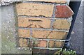
Ordnance Survey Cut Mark
This OS cut mark can be found on No36 Llwydarth Road. It marks a point 120.030m above mean sea level.
Image: © Adrian Dust
Taken: 11 Nov 2020
0.08 miles
3
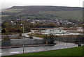
Waste ground viewed from Ewenny Road railway station, Maesteg
Viewed from the top of this http://www.geograph.org.uk/photo/4270433 station access ramp towards a large fenced-off area
of waste ground that looks like the site of a demolished factory or similar extensive building.
Image: © Jaggery
Taken: 30 Oct 2014
0.16 miles
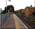
4
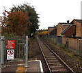
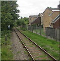
Towards Garth station from Ewenny Road, Maesteg
Looking towards a road bridge from the end of the platform at Ewenny Road on the Maesteg Line.
Garth station is about 750 metres ahead.
Image: © Jaggery
Taken: 30 Oct 2014
0.17 miles
5

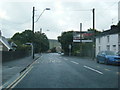
Unnamed road past the entrance to Ewenny Road railway station, Maesteg
The road ascends from Oakwood Drive towards the A4063. Though the central part of Ewenny Road (and this bridge http://www.geograph.org.uk/photo/4270077 ) is nearby, this road is the only access to the small station, which has no car park and few other facilities.
Image: © Jaggery
Taken: 30 Oct 2014
0.19 miles
6
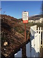
Railway Warning Notice
Warning sign near the Maesteg railway.
Image: © Alan Hughes
Taken: 19 Jan 2017
0.20 miles
8
Maesteg Line SE of Ewenny Road station, Maesteg
Viewed from here https://www.geograph.org.uk/photo/6893989. Garth is the next station ahead on the route to Bridgend.
Image: © Jaggery
Taken: 9 Jul 2021
0.21 miles
9
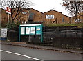
Information board and name sign, Ewenny Road railway station, Maesteg
Viewed across an unnamed connecting road between Oakwood Drive and the A4063.
Image: © Jaggery
Taken: 30 Oct 2014
0.22 miles
10
Houses opposite Ewenny Road railway station, Maesteg
The backs of houses in Bethania Close.
Image: © Jaggery
Taken: 30 Oct 2014
0.22 miles