IMAGES TAKEN NEAR TO
Nant Yr Crynwydd, MAESTEG, CF34 9ER
Introduction
This page details the photographs taken nearby to Nant Yr Crynwydd, CF34 9ER by members of the Geograph project.
The Geograph project started in 2005 with the aim of publishing, organising and preserving representative images for every square kilometre of Great Britain, Ireland and the Isle of Man.

There are currently over 7.5m images from over14,400 individuals and you can help contribute to the project by visiting https://www.geograph.org.uk
Image Map
Images are licensed for reuse under creativecommons.org/licenses/by-sa/2.0
Notes
- Clicking on the map will re-center to the selected point.
- The higher the marker number, the further away the image location is from the centre of the postcode.
Image Listing (104 Images Found)
Images are licensed for reuse under creativecommons.org/licenses/by-sa/2.0
Image
Details
Distance
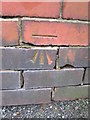
1
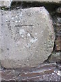
Ordnance Survey Cut Mark
This OS cut mark can be found on the wall to the south of the path. It marks a point 140.809m above mean sea level.
Image: © Adrian Dust
Taken: 9 Mar 2016
0.03 miles
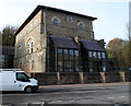
2
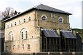
Part of the Maesteg Sports Centre
The former blast-engine house of the Llynfi Ironworks, now the Reception Area of the Maesteg Sports Centre.
Image: © David Lewis
Taken: Unknown
0.04 miles
3
Entrance to Maesteg RFC ground
The Llynfi Road ground is home to Maesteg Rugby Football Club, founded in 1877.
The following explanation of The Old Parish and 7777 on the wall is based on text on the club's website:
Maesteg's English translation is Fairfield. It is also known as Yr Hen Blwyf or The Old Parish, a name that is forever associated with the numerals 7777, or the Four Sevens. Popular versions of the origin of the Four Sevens are basically the same but it has become a theme with many variations and embellishments. This straightforward account has been taken from the book Tir Iarll (Earls Land) written by the Llangynwyd historian Mr Frederick Evans M.A. from the chapter on Legends
" A certain carpenter in the Parish of Llangynwyd had to make a coffin for a young man of twenty eight years of age. When he came to engrave the deceased's age on the coffin lid he became puzzled to how to express it in figures, possibly because he could not cope with the required curves of the two numerals. Recollecting that four sevens made twenty-eight solved the difficulty of inscribing 7 7 7 7 upon the coffin. Thus, says tradition, if one of the inhabitants could have lived so long then the Parish itself must be of a fabulous age. So with a touch of amusement and slight ridicule the Old Parish or Yr Hen Blwyf was born".
However plausible the story may be, it is fiction. The name Old Parish dates from the reign of Henry VIII and the dissolution of the monasteries. The turmoil of the period saw local churches from the surrounding areas being separated from the mother church of Llangynwyd. When the various boundaries were settled the parish of the mother church of Llangywnyd was known henceforth as The Old Parish.
Image: © Jaggery
Taken: 17 Nov 2011
0.04 miles
4
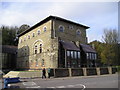
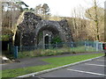
Blowing Engine House, Llynfi Ironworks
Restored and now part of the Maesteg Leisure Centre
Image: © Chris Andrews
Taken: 24 Oct 2012
0.06 miles
5
Ordnance Survey Cut Mark
This OS cut mark can be found on the wall of No1 Exchange Street. It marks a point 137.620m above mean sea level.
Image: © Adrian Dust
Taken: 9 Mar 2016
0.06 miles
6
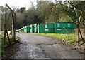
Recycling area near Maesteg Sports Centre
Labels on the two containers nearest the camera show CARDBOARD ONLY.
Image: © Jaggery
Taken: 17 Nov 2011
0.06 miles
7
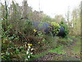
Tank near Maesteg Sports Centre
Shown on one map as "tank", this partly-overgrown black metal structure has a pipe attached to its left side. Current use, if any, of the tank is unknown to this contributor.
Image: © Jaggery
Taken: 17 Nov 2011
0.06 miles
8
Main entrance to Maesteg Sports Centre and Llynfi Library
The Bridgend County Borough Council buildings are part of a former iron forge site.
Image: © Jaggery
Taken: 17 Nov 2011
0.07 miles
9
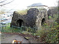
Former Llynvi Ironworks Furnace, Maesteg
Located near Maesteg Sports Centre and Llynfi Library. http://www.geograph.org.uk/photo/3005628
A small plaque on the structure shows
LLYNVI IRONWORKS
1838-1886
FURNACE NO. 4 BUILT 1850
CONSERVED 1995
OGWR BOROUGH COUNCIL
The semi-Anglicised spelling Llynvi was the usual 19th century version of Llynfi, the Welsh spelling.
Image: © Jaggery
Taken: 17 Nov 2011
0.07 miles
10
Former Llynvi Ironworks Furnace viewed from higher ground, Maesteg
Located near Maesteg Sports Centre and Llynfi Library. http://www.geograph.org.uk/photo/3005628
A small plaque on the structure shows
LLYNVI IRONWORKS
1838-1886
FURNACE NO. 4 BUILT 1850
CONSERVED 1995
OGWR BOROUGH COUNCIL
The semi-Anglicised spelling Llynvi was the usual 19th century version of Llynfi, the Welsh spelling.
Image: © Jaggery
Taken: 17 Nov 2011
0.07 miles