IMAGES TAKEN NEAR TO
Maesteg Row, MAESTEG, CF34 9DX
Introduction
This page details the photographs taken nearby to Maesteg Row, CF34 9DX by members of the Geograph project.
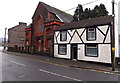
The Geograph project started in 2005 with the aim of publishing, organising and preserving representative images for every square kilometre of Great Britain, Ireland and the Isle of Man.

There are currently over 7.5m images from over14,400 individuals and you can help contribute to the project by visiting https://www.geograph.org.uk
Image Map
Images are licensed for reuse under creativecommons.org/licenses/by-sa/2.0
Notes
- Clicking on the map will re-center to the selected point.
- The higher the marker number, the further away the image location is from the centre of the postcode.
Image Listing (109 Images Found)
Images are licensed for reuse under creativecommons.org/licenses/by-sa/2.0
Image
Details
Distance
1
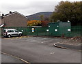
Gas installation on the north side of Ewenny Road, Maesteg
A notice on the Wales & West Utilities (WWU) gas installation shows a WWU Plant Protection phone number to ring before beginning any works on, or within 10 metres of, this site. No smoking.
Image: © Jaggery
Taken: 30 Oct 2014
0.05 miles
2
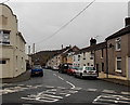
Cwmdu Street, Maesteg
Looking south across Bridgend Road. Cwmdu Street ends 150 metres ahead, at the edge of the River Llynfi.
Image: © Jaggery
Taken: 30 Oct 2014
0.06 miles
3
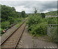
Maesteg Line from Ewenny Road station towards Maesteg station
Viewed from the NW end of Ewenny Road station looking along the single-track Maesteg Line towards the terminus at Maesteg station in July 2021. The railings on the left are at the edge of the bridge carrying the railway over Ewenny Road.
Image: © Jaggery
Taken: 9 Jul 2021
0.06 miles
4
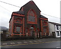
Former Bethlehem Welsh chapel (Presbyterian) in Maesteg
Located in Bethania Street, opposite Bethania Chapel. http://www.geograph.org.uk/photo/4225266 Built in 1905, Bethlehem was noted as
still in use in 1997. In late October 2014, the nameboard has gone and the lower windows are protected by sheeting.
Image: © Jaggery
Taken: 30 Oct 2014
0.06 miles
5
Black & white house and a former chapel in Maesteg
Viewed across Bethania Street. The house is on the corner of Ewenny Road,
next door to the former Bethlehem Welsh chapel. http://www.geograph.org.uk/photo/4270041
Image: © Jaggery
Taken: 30 Oct 2014
0.06 miles
6
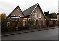
Catholic Social Club, Maesteg
Located in the Parish Hall, Ewenny Road.
Image: © Jaggery
Taken: 30 Oct 2014
0.06 miles
7
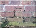
Ordnance Survey Cut Mark
This OS cut mark can be found on MET Fabrications. It marks a point 116.248m above mean sea level.
Image: © Adrian Dust
Taken: 11 Nov 2020
0.07 miles
8
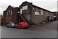
Boxing gym, Ewenny Road, Maesteg
At the top of steps, a sign in front of the first floor door shows BOXING GYM.
Business names in view are Met Fabrications (Maesteg) Ltd and E.L.J. Engineering.
Image: © Jaggery
Taken: 30 Oct 2014
0.07 miles
9
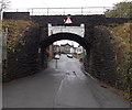
East side of Ewenny Road railway bridge, Maesteg
The bridge carries the Maesteg Line railway over Ewenny Road. Headroom shown is 3.6 metres (11' 9").
Ewenny Road railway station is 40 metres to the south (left). Bethania chapel http://www.geograph.org.uk/photo/4225266 is in the background.
Image: © Jaggery
Taken: 30 Oct 2014
0.07 miles
10
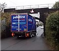
Is it going to make it? Ewenny Road, Maesteg
The lorry has stopped at the edge of this http://www.geograph.org.uk/photo/4225309 bridge. I thought - that's going to be a tight fit!
The driver made the wise choice - he reversed back down Ewenny Road. Before he did so,
he told me his lorry is 12' high. The headroom shown is 11' 9"...
Image: © Jaggery
Taken: 30 Oct 2014
0.07 miles