1
River Llynfi flows towards Meadow Street footbridge, Maesteg
Viewed from the footbridge http://www.geograph.org.uk/photo/4229075 from the southern end of Meadow Street to Commercial Street.
Image: © Jaggery
Taken: 17 Nov 2011
0.01 miles
2
The Maltsters Arms, Maesteg
Commercial Street pub, opposite Maesteg Police Station. http://www.geograph.org.uk/photo/2699231 Attractions include large screen televisions, live music (on the dates shown on a blackboard on the right side of the pub) and a pool table.
The Maltsters dates from the 1840s when it was a coaching inn. The pub's website points out this it is one of the few pubs in the Llynfi Valley to retain a portico with solid cast iron pillars.
Image: © Jaggery
Taken: 17 Nov 2011
0.01 miles
3
Pub sign, The Maltsters Arms, Maesteg
A depiction of a jovial maltster adorns the pub sign of the Commercial Street pub.
http://www.geograph.org.uk/photo/2699338
Image: © Jaggery
Taken: 17 Nov 2011
0.01 miles
4
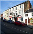
Victoria, Commercial Street, Maesteg
Business premises at 106 Commercial Street, on the corner of Station Hill. A sign depicting Queen Victoria hangs between first floor windows, above the doorway.
The right side of the premises appears to be a pub. The Chinese characters to the left of the doorway suggests that this part of the premises is a Chinese restaurant or takeaway.
Image: © Jaggery
Taken: 17 Nov 2011
0.01 miles
5
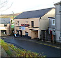
The Wellington, Maesteg
Church Street pub, viewed from near the Commercial Street junction.
Image: © Jaggery
Taken: 17 Nov 2011
0.01 miles
6
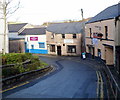
Three businesses on a bend in Church Street, Maesteg
Viewed from the Commercial Street end. On the right is The Wellington pub. http://www.geograph.org.uk/photo/2699373 In the middle is W.E. Ironmongers. On the left is Heritage Bathrooms.
Image: © Jaggery
Taken: 17 Nov 2011
0.01 miles
7
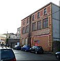
Faded lettering on a Church Street wall, Maesteg
There is faded and partly overwritten lettering on the Church Street side of premises in Commercial Street. Clearly readable are DRAPER FITTER and TAILOR.
Image: © Jaggery
Taken: 17 Nov 2011
0.01 miles
8
River Llynfi flows away from Church Street, Maesteg
Viewed from a small stone bridge. http://www.geograph.org.uk/photo/2699431
The Llynfi is a tributary of the River Ogmore, into which it flows at Aberkenfig.
Image: © Jaggery
Taken: 17 Nov 2011
0.01 miles
9
Former Family Value store for sale, Maesteg
There is a For Sale sign on the boarded-up former Family Value store at 38-42 Commercial Street.
Image: © Jaggery
Taken: 17 Nov 2011
0.01 miles
10
River Llynfi flows away from Meadow Street footbridge, Maesteg
Viewed from the footbridge http://www.geograph.org.uk/photo/4229075 connecting the southern end of Meadow Street with Commercial Street.
The Llynfi is a tributary of the River Ogmore, into which it flows at Aberkenfig.
Image: © Jaggery
Taken: 17 Nov 2011
0.05 miles


