IMAGES TAKEN NEAR TO
North Street, MAESTEG, CF34 0PH
Introduction
This page details the photographs taken nearby to North Street, CF34 0PH by members of the Geograph project.
The Geograph project started in 2005 with the aim of publishing, organising and preserving representative images for every square kilometre of Great Britain, Ireland and the Isle of Man.

There are currently over 7.5m images from over14,400 individuals and you can help contribute to the project by visiting https://www.geograph.org.uk
Image Map
Images are licensed for reuse under creativecommons.org/licenses/by-sa/2.0
Notes
- Clicking on the map will re-center to the selected point.
- The higher the marker number, the further away the image location is from the centre of the postcode.
Image Listing (77 Images Found)
Images are licensed for reuse under creativecommons.org/licenses/by-sa/2.0
Image
Details
Distance
1
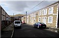
Alexandra Road, Caerau
Looking towards North Street from the edge of Alexandra Place.
Image: © Jaggery
Taken: 27 Feb 2015
0.02 miles
2
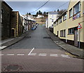
North Street, Caerau
Viewed across Caerau Road. Noddfa http://www.geograph.org.uk/photo/4364357 is on the left.
Image: © Jaggery
Taken: 27 Feb 2015
0.03 miles
3
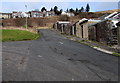
Northern end of an unnamed side street, Caerau
On the north side of Caerau Road, between the backs of North Street
houses on the right and George Street out of shot on the left.
Image: © Jaggery
Taken: 27 Feb 2015
0.04 miles
4
Alexandra Place, Caerau
Between Brynglas Terrace behind the camera and Alexandra Road ahead.
Image: © Jaggery
Taken: 27 Feb 2015
0.04 miles
5
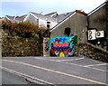
Noddfa mural, Caerau
The colourful NW corner of Noddfa. http://www.geograph.org.uk/photo/4364368
Image: © Jaggery
Taken: 27 Feb 2015
0.05 miles
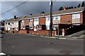
6

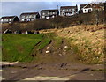
Victoria Street houses, Caerau
On the north side of the street, near its eastern end.
Image: © Jaggery
Taken: 27 Feb 2015
0.05 miles
7
Track towards George Street, Caerau
Vehicle tracks show that some drivers have taken a shortcut between George Street (out of shot on the left) and Caerau Road behind the camera. Boulders ahead suggest that this route has now been blocked. Cymmer Road houses are in the background.
Image: © Jaggery
Taken: 27 Feb 2015
0.06 miles
8
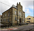
West side of Noddfa Chapel, Caerau
Viewed across Caerau Road. The inscription in Welsh above the door shows that Noddfa was built as a Welsh Baptist chapel in 1898.
Image: © Jaggery
Taken: 27 Feb 2015
0.06 miles
9
East side of Noddfa Chapel, Caerau
On the corner of Caerau Road and North Street. The inscription in Welsh above the door shows that Noddfa was built as a Welsh Baptist chapel in 1898.
Image: © Jaggery
Taken: 27 Feb 2015
0.06 miles
10
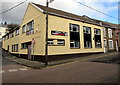
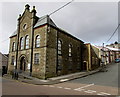
Former Caerau Labour Club, Caerau
In late February 2015, there is no nameboard on the premises on the corner of Caerau Road and North Street, opposite Noddfa. http://www.geograph.org.uk/photo/4364368
Image: © Jaggery
Taken: 27 Feb 2015
0.06 miles