IMAGES TAKEN NEAR TO
Bangor Street, MAESTEG, CF34 0LA
Introduction
This page details the photographs taken nearby to Bangor Street, CF34 0LA by members of the Geograph project.
The Geograph project started in 2005 with the aim of publishing, organising and preserving representative images for every square kilometre of Great Britain, Ireland and the Isle of Man.

There are currently over 7.5m images from over14,400 individuals and you can help contribute to the project by visiting https://www.geograph.org.uk
Image Map
Images are licensed for reuse under creativecommons.org/licenses/by-sa/2.0
Notes
- Clicking on the map will re-center to the selected point.
- The higher the marker number, the further away the image location is from the centre of the postcode.
Image Listing (50 Images Found)
Images are licensed for reuse under creativecommons.org/licenses/by-sa/2.0
Image
Details
Distance
1
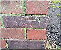
Ordnance Survey Cut Mark
This OS cut mark can be found on Nantyffyllan Sub-station, Bangor Street. It marks a point 151.946m above mean sea level.
Image: © Adrian Dust
Taken: 10 Nov 2020
0.02 miles
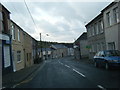
2
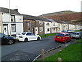
Northern side of Grove Street, Nantyffyllon
Viewed from Picton Street.
Image: © Jaggery
Taken: 17 Nov 2011
0.03 miles
3
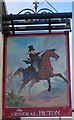
The General Picton pub sign, Nantyffyllon
This curious depiction of Lieutenant General Sir Thomas Picton is the pub sign here. http://www.geograph.org.uk/photo/3009802
With black top hat and tailcoat, he appears to be a Georgian gentleman out for a ride in the countryside, yet he is holding a sabre, there are troops behind him, and the scene looks like part of a battlefield.
Image: © Jaggery
Taken: 17 Nov 2011
0.03 miles
4
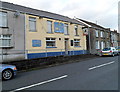
The General Picton, Nantyffyllon
Pub and 40-seat restaurant in Picton Place, viewed from the corner of Grove Street. http://www.geograph.org.uk/photo/3009792
Lieutenant General Sir Thomas Picton, the most senior officer to die at the Battle of Waterloo (June 1815), was born in Pembrokeshire, Wales, in 1758.
Image: © Jaggery
Taken: 17 Nov 2011
0.03 miles
6
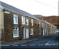
Hill Street, Nantyffyllon
Viewed from opposite the Kingdom Hall. http://www.geograph.org.uk/photo/3009873 All eight Hill Street houses are on this side of the street.
Image: © Jaggery
Taken: 17 Nov 2011
0.05 miles
7
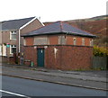
Electricity substation, Nantyffyllon
Located in Bangor Terrace. Trinity Presbyterian Church http://www.geograph.org.uk/photo/3009738 is just out of shot on the right.
Image: © Jaggery
Taken: 17 Nov 2011
0.05 miles
8
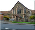
Trinity Presbyterian Church, Nantyffyllon
Located in Bangor Terrace, on the eastern edge of residential Nantyffyllon.
Image: © Jaggery
Taken: 17 Nov 2011
0.05 miles
9
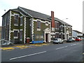
Nantyffyllon Institute viewed from the north
Also referred to as Norths Memorial Hall. An inscription in stone on the building shows NANTYFFYLLON WORKMENS INSTITUTE 1926. There are six foundation stones visible, at a level a little higher than the tops of the cars. The stones show the date August 22nd 1925.
Facilities available include a gym, concert rooms, a games room, meeting/training rooms, a creche and kitchen. Activities and groups using the institute include religious meetings and Sunday School, Welsh Education Authority, a youth club, keep fit, an advice & information centre, Mothers and Toddlers group, bingo club and dog training classes.
Image: © Jaggery
Taken: 17 Nov 2011
0.05 miles
10
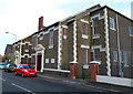
Nantyffyllon Institute viewed from the SW
Also referred to as Norths Memorial Hall. An inscription in stone on the building shows NANTYFFYLLON WORKMENS INSTITUTE 1926. There are several foundation stones, two of which can be seen on the right side of the doorway, showing the date August 22nd 1925.
Facilities available include a gym, concert rooms, a games room, meeting/training rooms, a creche and kitchen. Activities and groups using the institute include religious meetings and Sunday School, Welsh Education Authority, a youth club, keep fit, an advice & information centre, Mothers and Toddlers group, bingo club and dog training classes.
Image: © Jaggery
Taken: 17 Nov 2011
0.05 miles