IMAGES TAKEN NEAR TO
Cwmdu, MAESTEG, CF34 0DH
Introduction
This page details the photographs taken nearby to CF34 0DH by members of the Geograph project.
The Geograph project started in 2005 with the aim of publishing, organising and preserving representative images for every square kilometre of Great Britain, Ireland and the Isle of Man.

There are currently over 7.5m images from over14,400 individuals and you can help contribute to the project by visiting https://www.geograph.org.uk
Image Map
Images are licensed for reuse under creativecommons.org/licenses/by-sa/2.0
Notes
- Clicking on the map will re-center to the selected point.
- The higher the marker number, the further away the image location is from the centre of the postcode.
Image Listing (8 Images Found)
Images are licensed for reuse under creativecommons.org/licenses/by-sa/2.0
Image
Details
Distance
1
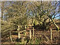
Public Footpath at Blaen Cwmdu
The footpath leads from Garth to Blaengarw over the Garw Forest.
Image: © Alan Hughes
Taken: 27 Dec 2017
0.07 miles
2
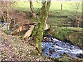
Bridge over Nant Cwmdu
Rustic bridge constructed for sheep to cross the Nant Cwmdu.
Image: © Alan Hughes
Taken: 27 Dec 2017
0.09 miles
3
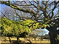
Mossy branch
A moss-covered branch glows in the low winter sunlight.
Image: © Alan Hughes
Taken: 27 Dec 2017
0.10 miles
4
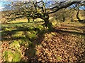
Footpath and wall
The footpath to Blaengarw runs alongside an old wall that is almost obscured by moss. Gnarled trees line the footpath.
Image: © Alan Hughes
Taken: 27 Dec 2017
0.11 miles
5
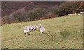
Welsh mountain sheep
This group of sheep are on a hill farm near Swansea.
Image: © Bill Kasman
Taken: 17 Nov 2019
0.19 miles
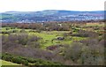
6
Blaen Cwmdu
Cerddwyr gerllaw ffermdy o'r enw Blaen Cwmdu.
Walkers near a farm known as Blaen Cwmdu (trans. source of black valley stream).
Image: © Alan Richards
Taken: 17 Jun 2012
0.20 miles
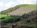
7
Spoil tip, Cwm Du
A view of the disused tip which is marked on Ordnance Survey's 1:25,000 map, and the contours of which can be seen on the 1:50,000 version. Beneath the vegetation it consists of spoil from mining work at St John's Colliery, also known as Cwmdu Colliery, which closed in 1985.
Image: © eswales
Taken: 5 Mar 2009
0.21 miles
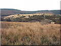
8
Disused coal mine
In centre frame can be seen the location of a former coal mine. St Johns Colliery was opened by North's Navigation Collieries Ltd. in 1910 on the site of the defunct Cwmdu Colliery. St Johns was the last deep mine in the Llynfi Valley and employed nearly 1500 miners. It closed in 1985. This image was taken from its spoil heap.
Image: © Bill Kasman
Taken: 17 Nov 2019
0.23 miles