IMAGES TAKEN NEAR TO
Llwyn Derw Avenue, MAESTEG, CF34 0BX
Introduction
This page details the photographs taken nearby to Llwyn Derw Avenue, CF34 0BX by members of the Geograph project.
The Geograph project started in 2005 with the aim of publishing, organising and preserving representative images for every square kilometre of Great Britain, Ireland and the Isle of Man.

There are currently over 7.5m images from over14,400 individuals and you can help contribute to the project by visiting https://www.geograph.org.uk
Image Map
Images are licensed for reuse under creativecommons.org/licenses/by-sa/2.0
Notes
- Clicking on the map will re-center to the selected point.
- The higher the marker number, the further away the image location is from the centre of the postcode.
Image Listing (138 Images Found)
Images are licensed for reuse under creativecommons.org/licenses/by-sa/2.0
Image
Details
Distance
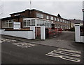
1
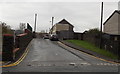
Towards Llwynderw Avenue, Maesteg
A short, gentle ascent from Bridgend Road leads to houses in Llwynderw Avenue.
Image: © Jaggery
Taken: 30 Oct 2014
0.01 miles
2
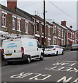
Engie van in Cemetery Road, Maesteg
Engie is a French multinational electric utility company which operates
in the fields of electricity generation and distribution, natural gas and renewable energy.
Image: © Jaggery
Taken: 17 Feb 2017
0.03 miles
3
Junction ahead on Bridgend Road, Maesteg
Viewed from the corner of Greenfield Street. http://www.geograph.org.uk/photo/4230346 The sign shows to turn right ahead for
Ewenny Road Industrial Estate, or stay on Bridgend Road for Garth, Cwmfelin and Llangynwyd.
Image: © Jaggery
Taken: 30 Oct 2014
0.04 miles
4
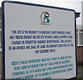
Bridgend County Borough Council notice outside Hyfrydol, Cemetery Road, Maesteg
The bilingual (English/Welsh) notice is located just out of shot on the left here, http://www.geograph.org.uk/photo/5285744 outside Hyfrydol Home for the Elderly.
Image: © Jaggery
Taken: 17 Feb 2017
0.04 miles
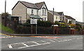
5
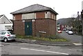
Turberville Street electricity substation, Maesteg
The Western Power Distribution electricity substation is on the corner of Turberville Street and Cemetery Road.
Image: © Jaggery
Taken: 17 Feb 2017
0.04 miles
6
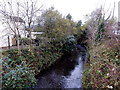
Upstream along the Llynfi from Ewenny Road, Maesteg
Looking north from this http://www.geograph.org.uk/photo/4225198 bridge.
Image: © Jaggery
Taken: 30 Oct 2014
0.05 miles
7
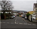
Cemetery Road, Maesteg
Viewed across Bridgend Road. This way to Maesteg Cemetery, about 500 metres ahead.
Image: © Jaggery
Taken: 17 Feb 2017
0.05 miles
8
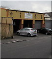
Turbovil Garage, Cemetery Road, Maesteg
Car servicing, repairs and sales business near the corner of Bridgend Road.
Image: © Jaggery
Taken: 17 Feb 2017
0.05 miles
9
Hyfrydol entrance, Maesteg
The Cemetery Road entrance to Hyfrydol Home for the Elderly.
Image: © Jaggery
Taken: 17 Feb 2017
0.05 miles
10
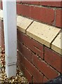
Ordnance Survey Cut Mark
This OS cut mark can be found on No66 Cemetery Road. It marks a point 124.624m above mean sea level.
Image: © Adrian Dust
Taken: 11 Nov 2020
0.05 miles