IMAGES TAKEN NEAR TO
Macgregor Row, MAESTEG, CF34 0AP
Introduction
This page details the photographs taken nearby to Macgregor Row, CF34 0AP by members of the Geograph project.
The Geograph project started in 2005 with the aim of publishing, organising and preserving representative images for every square kilometre of Great Britain, Ireland and the Isle of Man.

There are currently over 7.5m images from over14,400 individuals and you can help contribute to the project by visiting https://www.geograph.org.uk
Image Map
Images are licensed for reuse under creativecommons.org/licenses/by-sa/2.0
Notes
- Clicking on the map will re-center to the selected point.
- The higher the marker number, the further away the image location is from the centre of the postcode.
Image Listing (43 Images Found)
Images are licensed for reuse under creativecommons.org/licenses/by-sa/2.0
Image
Details
Distance
1

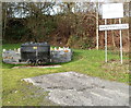
A relic of Mid Glamorgan Water Board, Nantyffyllon
Viewed across the A4063. The building on the bank of the River Llynfi is now part of a Welsh Water pumping station. On its wall are the blue initials M.G.W.B, the abbreviation of Mid Glamorgan Water Board, a public sector undertaking that in 1973 became part of the Welsh National Water Development Authority (later known as the Welsh Water Authority, which was privatised in 1974 to become Welsh Water).
Image: © Jaggery
Taken: 17 Nov 2011
0.02 miles
2
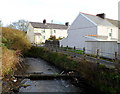
River Llynfi flows towards the A4063, Nantyffyllon
Viewed from this bridge http://www.geograph.org.uk/photo/3006446 at the boundary of Maesteg and Nantyffyllon.
The house in the foreground is in MacGregor Row. The one in the background is in Charles Row.
Image: © Jaggery
Taken: 17 Nov 2011
0.02 miles
3
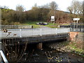
River Llynfi bridge, Nantyffyllon
The Llynfi flows under the A4063. In the background, centre right, is a coal dram.http://www.geograph.org.uk/photo/3006260
Image: © Jaggery
Taken: 17 Nov 2011
0.02 miles
4
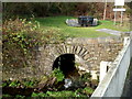
Outfall into the River Llynfi at the Maesteg/Nantyffyllon boundary
Above the outfall through a stone arch is a coal dram http://www.geograph.org.uk/photo/3006260
Image: © Jaggery
Taken: 17 Nov 2011
0.02 miles
5
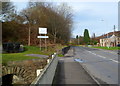
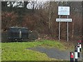
Southern boundary of Nantyffyllon
The boundary between Maesteg and Nantyffyllon is here marked by the River Llynfi which flows under the A4063 at this point. Castle Street Maesteg on this side of the river becomes High Street Nantyffyllon ahead. On the left is a coal dram. http://www.geograph.org.uk/photo/3006260
Image: © Jaggery
Taken: 17 Nov 2011
0.02 miles
6
Coal dram alongside the Nantyffyllon boundary
Located on the west side of the A4063, at the Maesteg/Nantyffyllon boundary.
A plaque on the dram records that it was found on the hillside above Coegnant Colliery (open 1882-1981) by members of the community in Nantyffyllon.
Dram is a variant spelling of tram, a truck used in mines.
Image: © Jaggery
Taken: 17 Nov 2011
0.02 miles
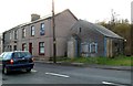
7
Coronation Terrace, Forge Industrial Estate
Image: © Kev Griffin
Taken: 18 Oct 2007
0.05 miles
8
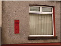
Maesteg: postbox № CF34 11, Castle Street
A Victorian postbox set into the wall of a house on the main road, along which we are looking towards the town centre. The box is currently missing its collection-times plate.
Image: © Chris Downer
Taken: 1 Feb 2010
0.06 miles
9
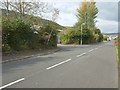
Housing Renewal Area
Area based renewal schemes enable local authorities to focus activity and investment on areas that combine a need for assistance with the potential for regeneration. Adjacent to the sign is a relic of the mining era when there would have been no need for any thought of regeneration.
Image: © Alan Hughes
Taken: 1 Feb 2017
0.06 miles
10
Boarded-up building, Castle Street, Maesteg
There was nothing remaining on the exterior of this boarded-up small building to indicate its former use. One map shows "Talgarth Bakeries". If that is correct, the current Talgarth Bakery http://www.geograph.org.uk/photo/2698689 in Maesteg is certainly a huge contrast!
Image: © Jaggery
Taken: 17 Nov 2011
0.06 miles