IMAGES TAKEN NEAR TO
Kenfig Hill, BRIDGEND, CF33 6RD
Introduction
This page details the photographs taken nearby to CF33 6RD by members of the Geograph project.
The Geograph project started in 2005 with the aim of publishing, organising and preserving representative images for every square kilometre of Great Britain, Ireland and the Isle of Man.

There are currently over 7.5m images from over14,400 individuals and you can help contribute to the project by visiting https://www.geograph.org.uk
Image Map (Loading...)


Getting Data...Please wait
Leaflet Map data © OpenStreetMap
Images are licensed for reuse under creativecommons.org/licenses/by-sa/2.0
Notes
- Clicking on the map will re-center to the selected point.
- The higher the marker number, the further away the image location is from the centre of the postcode.
Image Listing (10 Images Found)
Images are licensed for reuse under creativecommons.org/licenses/by-sa/2.0
Image
Details
Distance
2
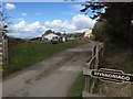
Public footpath/farm lane to the north east of Hafodheulog
Looking south west down the farm lane in the south west corner of the grid square. At this point the lane serves also as a public footpath.
Image: © eswales
Taken: 25 Jun 2008
0.09 miles
3

Gate and Fencing
Gate and line of fencing at the highest point above Pentitla Farm.
Image: © Alan Hughes
Taken: 27 Apr 2016
0.11 miles
4

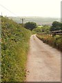
Narrow lane with tall hedgerows to the north east of Hafodheulog
Part of a particularly narrow and enclosed section of the lane which runs through the grid square lying in the southern half of the square.
Image: © eswales
Taken: 25 Jun 2008
0.13 miles
5
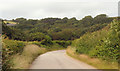
Hafodheulog Wood (north east)
The north east corner of Hafodheulog Wood as seen, looking approximately north-northwest, from the lane in the east of the grid square.
Image: © eswales
Taken: 25 Jun 2008
0.13 miles
6

Hidden Steps
Woodland undergrowth conceals a stairway of stone steps which rise up to ruined quarry buildings.
Image: © Alan Hughes
Taken: 27 Apr 2016
0.14 miles
7
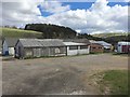
Pentitla Farm
Farm buildings at Pentitla.
Image: © Alan Hughes
Taken: 27 Apr 2016
0.16 miles
8
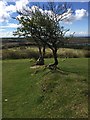
Trees on Hedge Line
Gnarled trees set on a low bank mark the line of an old hedgerow.
Visible in the middle distance are the opencast workings of Cefn Cribwr, with the quarry lake to the right. North Devon lies in the distance across the Bristol Channel.
Image: © Alan Hughes
Taken: 27 Apr 2016
0.18 miles
9
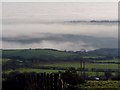
Southern slope of Margam Mountain.
Southern slope of Margam Mountain, with lowland fog covering the open cast site in the middle ground and with the ridge-top village of Cefn Cribwr outlined above the fog in the distance.
Image: © David Lewis
Taken: Unknown
0.18 miles
10

Disused Quarry Building
The silhouette of a disused quarry building looms against the skyline, shrouded by ivy and screened by lanky hedge growth.
Image: © Alan Hughes
Taken: 27 Apr 2016
0.22 miles