IMAGES TAKEN NEAR TO
North Avenue, BRIDGEND, CF33 6ND
Introduction
This page details the photographs taken nearby to North Avenue, CF33 6ND by members of the Geograph project.
The Geograph project started in 2005 with the aim of publishing, organising and preserving representative images for every square kilometre of Great Britain, Ireland and the Isle of Man.

There are currently over 7.5m images from over14,400 individuals and you can help contribute to the project by visiting https://www.geograph.org.uk
Image Map
Images are licensed for reuse under creativecommons.org/licenses/by-sa/2.0
Notes
- Clicking on the map will re-center to the selected point.
- The higher the marker number, the further away the image location is from the centre of the postcode.
Image Listing (40 Images Found)
Images are licensed for reuse under creativecommons.org/licenses/by-sa/2.0
Image
Details
Distance
1
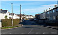
North Avenue, Kenfig Hill
Viewed across Marshfield Avenue. The boundary between Pyle and Kenfig Hill is unclear to me in this area. I've used Kenfig Hill because that's what most on-line references use for North Avenue.
Image: © Jaggery
Taken: 29 Nov 2012
0.01 miles
2
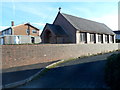
The Catholic Church of St Joseph of Arimathea, Kenfig Hill
Located on the south side of Pisgah Street.
Image: © Jaggery
Taken: 29 Nov 2012
0.03 miles
3
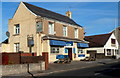
Walnut Tree pub to let, Kenfig Hill
There are To Let signs on the Walnut Tree pub at 110 Pisgah Street, Kenfig Hill.
Image: © Jaggery
Taken: 29 Nov 2012
0.04 miles
4
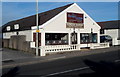
Bengal Lounge, Kenfig Hill
Bangladeshi & Indian cuisine restaurant located on the north side of Pisgah Street, next door to the Walnut Tree pub. http://www.geograph.org.uk/photo/3254976 The Bengal Lounge occupies a building about 10 metres across on the street side, but extending back for about 30 metres.
Image: © Jaggery
Taken: 29 Nov 2012
0.05 miles
5
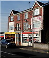
Ladbrokes and Royal Garden, Kenfig Hill
The two Pisgah Street businesses are a Ladbrokes betting shop
and Royal Garden Chinese and Cantonese cuisine takeaway.
Image: © Jaggery
Taken: 29 Nov 2012
0.05 miles
6
Barrie David dental practice, Kenfig Hill
The single-storey building at 88 Pisgah Street is the dental practice of Barrie David & Associates.
Image: © Jaggery
Taken: 29 Nov 2012
0.06 miles
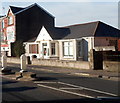
7

Pisgah Baptist Chapel and chapelyard, Kenfig Hill
Viewed from Pisgah Road. The chapel is a 1912 rebuild of the 1857 rebuild of the original 1836 chapel.
Image: © Jaggery
Taken: 29 Nov 2012
0.06 miles
8

Pisgah Baptist Chapel, Kenfig Hill
Located on the corner of Pisgah Street and Baiden Avenue,
the chapel is a 1912 rebuild of the 1857 rebuild of the original 1836 chapel.
Image: © Jaggery
Taken: 29 Nov 2012
0.06 miles
9
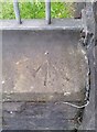
Ordnance Survey Rivet
This OS rivet can be found on the wall of the Pisgah Chapel, Pisgah Street. It marks a point 51.517m above mean sea level.
Image: © Adrian Dust
Taken: 18 Aug 2021
0.06 miles
10
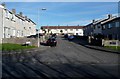
Cribbwr Square, Kenfig Hill
Viewed from Marshfield Avenue. The boundary between Pyle and Kenfig Hill is unclear to me in this area. I've used Kenfig Hill because that's what most on-line references use for Cribbwr Square.
Image: © Jaggery
Taken: 29 Nov 2012
0.08 miles