IMAGES TAKEN NEAR TO
Helig Fan, BRIDGEND, CF33 6NA
Introduction
This page details the photographs taken nearby to Helig Fan, CF33 6NA by members of the Geograph project.
The Geograph project started in 2005 with the aim of publishing, organising and preserving representative images for every square kilometre of Great Britain, Ireland and the Isle of Man.

There are currently over 7.5m images from over14,400 individuals and you can help contribute to the project by visiting https://www.geograph.org.uk
Image Map
Images are licensed for reuse under creativecommons.org/licenses/by-sa/2.0
Notes
- Clicking on the map will re-center to the selected point.
- The higher the marker number, the further away the image location is from the centre of the postcode.
Image Listing (52 Images Found)
Images are licensed for reuse under creativecommons.org/licenses/by-sa/2.0
Image
Details
Distance
1
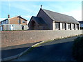
The Catholic Church of St Joseph of Arimathea, Kenfig Hill
Located on the south side of Pisgah Street.
Image: © Jaggery
Taken: 29 Nov 2012
0.04 miles
2

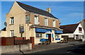
Pisgah Street bungalows, Kenfig Hill
There were no boundary signs here, but as far as I can tell these bungalows on the north side of the B4281 Pisgah Street are at the western edge of the village of Kenfig Hill, adjacent to the eastern edge
of the village of Pyle.
Image: © Jaggery
Taken: 29 Nov 2012
0.04 miles
3
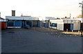
Main entrance to Pyle Life Centre
Viewed from Marshfield Avenue. Pyle Life Centre is a combined public library and leisure centre.
Image: © Jaggery
Taken: 29 Nov 2012
0.05 miles
4
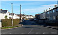
North Avenue, Kenfig Hill
Viewed across Marshfield Avenue. The boundary between Pyle and Kenfig Hill is unclear to me in this area. I've used Kenfig Hill because that's what most on-line references use for North Avenue.
Image: © Jaggery
Taken: 29 Nov 2012
0.06 miles
5
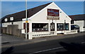
Pyle Fish Bar
Viewed from the corner of Marshfield Avenue, Pyle Fish Bar is at number 1, Ffald Road (the B4281).
To the east (right) of the fish bar, the B4281 is renamed Pisgah Street.
Image: © Jaggery
Taken: 29 Nov 2012
0.06 miles
6
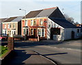
Walnut Tree pub to let, Kenfig Hill
There are To Let signs on the Walnut Tree pub at 110 Pisgah Street, Kenfig Hill.
Image: © Jaggery
Taken: 29 Nov 2012
0.06 miles
7
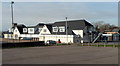
South side of Pyle Life Centre buildings
Viewed from Marshfield Avenue. Pyle Life Centre is a combined public library and leisure centre.
Image: © Jaggery
Taken: 29 Nov 2012
0.07 miles
8
Pyle Swimming Pool
Viewed from Marshfield Avenue.
Image: © Jaggery
Taken: 29 Nov 2012
0.07 miles
9
Bengal Lounge, Kenfig Hill
Bangladeshi & Indian cuisine restaurant located on the north side of Pisgah Street, next door to the Walnut Tree pub. http://www.geograph.org.uk/photo/3254976 The Bengal Lounge occupies a building about 10 metres across on the street side, but extending back for about 30 metres.
Image: © Jaggery
Taken: 29 Nov 2012
0.08 miles
10
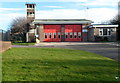
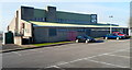
Kenfig Hill fire station and training tower
Somewhat confusingly, Kenfig Hill fire station is in Pyle, on the south side of Fflad Road.
The coterminous village of Kenfig Hill is located on the NE side of Pyle, some distance from here.
The fire station, part of the South Wales Fire and Rescue Service, covers the Pyle, Kenfig Hill, Cefn Cribwr, Cornelly, and Kenfig Pool areas, about 10 square miles with a total population c 16,000.
Image: © Jaggery
Taken: 29 Nov 2012
0.08 miles