IMAGES TAKEN NEAR TO
Commercial Street, BRIDGEND, CF33 6DL
Introduction
This page details the photographs taken nearby to Commercial Street, CF33 6DL by members of the Geograph project.
The Geograph project started in 2005 with the aim of publishing, organising and preserving representative images for every square kilometre of Great Britain, Ireland and the Isle of Man.

There are currently over 7.5m images from over14,400 individuals and you can help contribute to the project by visiting https://www.geograph.org.uk
Image Map
Images are licensed for reuse under creativecommons.org/licenses/by-sa/2.0
Notes
- Clicking on the map will re-center to the selected point.
- The higher the marker number, the further away the image location is from the centre of the postcode.
Image Listing (45 Images Found)
Images are licensed for reuse under creativecommons.org/licenses/by-sa/2.0
Image
Details
Distance
1

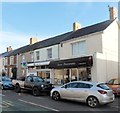
Sweetie-licious, Kenfig Hill
The shop at 27 Commercial Street sells sweets,
lollipops and other confectionery, soft drinks and ice cream.
Image: © Jaggery
Taken: 29 Nov 2012
0.02 miles
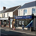
2
Lloyds TSB Kenfig Hill
The Kenfig Hill bank branch, sort code 30-96-82, is at 57 Commercial Street
next door to Aaron Photography.
Image: © Jaggery
Taken: 29 Nov 2012
0.04 miles
3
DataKom, Kenfig Hill
Providers of business telecom and IT, located at 60 Commercial Street
next door to Warburton's Family Butchers at number 62.
Image: © Jaggery
Taken: 29 Nov 2012
0.05 miles
4
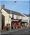
Booze and butchery in Kenfig Hill
Bargain Booze is at 64 Commercial Street.
At number 62 is Warburton's Family Butchers.
Image: © Jaggery
Taken: 29 Nov 2012
0.05 miles
5
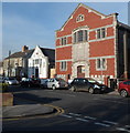
Former St David's church, Kenfig Hill
Viewed along Waunbant Road from the corner of Park Street. The larger, mainly brick,
building is the disused St David's church. The inscription in stone above the doorway is
ST DAVID'S PRESBYTERIAN CHURCH IN WALES 1928.
The smaller white building is the former vestry, latterly used for worship instead of the larger building. There was no name board to indicate that this is still in use. The year 1909 is inscribed in stone on the facade of the vestry. Waunbant Road is also known locally as Stormy Road, because it leads to Stormy Down near Bridgend.
Image: © Jaggery
Taken: 29 Nov 2012
0.06 miles
6
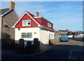
The Old Telephone Exchange, Kenfig Hill
Now in residential use, this Waunbant Road building bears the nameplate The Old Telephone Exchange. Doubtless it has been much altered, internally and externally, since its change of use.
The coaches in the background are at the edge of the Express Motors depot.
Image: © Jaggery
Taken: 29 Nov 2012
0.06 miles
7
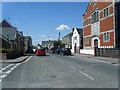
Waunbant Road approaching Commercial Street
Image: © Colin Pyle
Taken: 27 Aug 2010
0.07 miles
8

Monmouthshire Building Society agency, Kenfig Hill
The Kenfig Hill agency is inside the premises of Elite Independent Mortgages Ltd
at 61 Commercial Street, on the corner of Waunbant Road.
Image: © Jaggery
Taken: 29 Nov 2012
0.07 miles
9

Former Carolanne shop, Kenfig Hill
Located on the corner of Waunbant Road and Bridge Street.
The name and business details (nursery equipment and baby wear) remain on the shop front though there is no stock inside. A Google Earth Street View taken more than three years earlier, in August 2009, also showed an empty shop.
Image: © Jaggery
Taken: 29 Nov 2012
0.07 miles
10
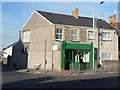
Corner fish and chip shop, Kenfig Hill
There is no name sign on the green frontage of this fish and chip shop on the corner of High Street
and Croft Goch Road. There is a small sign in the window showing Fish & Chips.
Image: © Jaggery
Taken: 29 Nov 2012
0.08 miles