IMAGES TAKEN NEAR TO
Brynglas Terrace, BRIDGEND, CF33 6AG
Introduction
This page details the photographs taken nearby to Brynglas Terrace, CF33 6AG by members of the Geograph project.
The Geograph project started in 2005 with the aim of publishing, organising and preserving representative images for every square kilometre of Great Britain, Ireland and the Isle of Man.

There are currently over 7.5m images from over14,400 individuals and you can help contribute to the project by visiting https://www.geograph.org.uk
Image Map
Images are licensed for reuse under creativecommons.org/licenses/by-sa/2.0
Notes
- Clicking on the map will re-center to the selected point.
- The higher the marker number, the further away the image location is from the centre of the postcode.
Image Listing (77 Images Found)
Images are licensed for reuse under creativecommons.org/licenses/by-sa/2.0
Image
Details
Distance
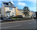
1
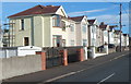
Brynglas Terrace houses, Pyle
Viewed from the Pandy Crescent end. There are houses on only this side of Brynglas Terrace.
The opposite side is the edge of Pyle Rugby Football Club's ground.
Image: © Jaggery
Taken: 29 Nov 2012
0.02 miles
2
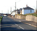
Brynglas Terrace, Pyle
Viewed from the A48 end looking towards Pyle railway station and Pyle rugby club.
Image: © Jaggery
Taken: 29 Nov 2012
0.06 miles
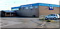
3
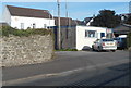
Avacab, Pyle
Taxi office in Brynglas Terrace, near the corner of Pyle Road (the A48).
Image: © Jaggery
Taken: 29 Nov 2012
0.06 miles
4
Path from Pyle railway station approaches Beach Road
The c200 metre long access footpath from the station http://www.geograph.org.uk/photo/3251359 approaches Beach Road,
curiously named as it is nowhere near a beach. The station car park is on the right.
Image: © Jaggery
Taken: 29 Nov 2012
0.07 miles
5
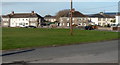
Pandy Crescent, Pyle
Viewed across a large grass semicircle from near Pyle RFC's clubhouse. http://www.geograph.org.uk/photo/3251246
Image: © Jaggery
Taken: 29 Nov 2012
0.07 miles
6
Welcome to Pyle RFC
The clubhouse is located in the SW corner of Pyle Rugby Football Club's ground
at the eastern end of Beach Road, near the entrance to Pyle railway station.
Image: © Jaggery
Taken: 29 Nov 2012
0.07 miles
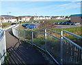
7
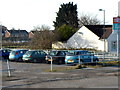
A corner of Pyle railway station car park
Viewed from near the Pyle RFC clubhouse. http://www.geograph.org.uk/photo/3251246 The small car park (capacity 15 cars)
is alongside part of the c200 metre long footpath to Pyle railway station.
Another small car park http://www.geograph.org.uk/photo/5410768 is on the opposite side of the station.
Image: © Jaggery
Taken: 29 Nov 2012
0.08 miles
8
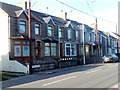
Victoria Terrace, Pyle
Victoria Terrace is a separately-named group of houses on the west side of Pyle Road (the A48).
Image: © Jaggery
Taken: 29 Nov 2012
0.08 miles
9
Tower House and Tower Cottage, Pyle
Viewed across Pyle Road (the A48). Tower House is on the left, Tower Cottage is on the right.
Image: © Jaggery
Taken: 29 Nov 2012
0.08 miles
10
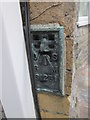
Ordnance Survey Flush Bracket (S1251)
This OS Flush Bracket can be found on No26 Pyle Road. It marks a point 37.269m above mean sea level.
Image: © Adrian Dust
Taken: 5 Jul 2015
0.08 miles