IMAGES TAKEN NEAR TO
Heol Y Sheet, Stormy Down, BRIDGEND, CF33 4RY
Introduction
This page details the photographs taken nearby to Heol Y Sheet, Stormy Down, CF33 4RY by members of the Geograph project.
The Geograph project started in 2005 with the aim of publishing, organising and preserving representative images for every square kilometre of Great Britain, Ireland and the Isle of Man.

There are currently over 7.5m images from over14,400 individuals and you can help contribute to the project by visiting https://www.geograph.org.uk
Image Map
Images are licensed for reuse under creativecommons.org/licenses/by-sa/2.0
Notes
- Clicking on the map will re-center to the selected point.
- The higher the marker number, the further away the image location is from the centre of the postcode.
Image Listing (20 Images Found)
Images are licensed for reuse under creativecommons.org/licenses/by-sa/2.0
Image
Details
Distance
1
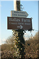
Stoney Barn
Barn conversion near Ballas Farm.
Image: © Alan Hughes
Taken: 7 Jun 2016
0.02 miles
2
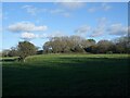
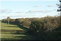
Wooded countryside by Ballas Farm, near Stormy Down
A view from the public footpath which runs northwards from Heol-y-Sheet to cross the M4.
Image: © eswales
Taken: 4 Nov 2021
0.08 miles
3
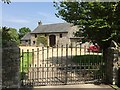
Signs beside Heol-y-Sheet, nr North Cornelly
Signage for tea rooms and a guest house beside the country lane.
Image: © eswales
Taken: 24 Feb 2016
0.10 miles
5
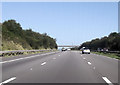
Field boundary and trees by the M4 near North Cornelly
Lines of trees either side of the motorway are seen here.
Image: © eswales
Taken: 4 Nov 2021
0.17 miles
6
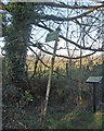
Public footpath sign and information board beside Heol-y-Sheet
The two are situated by the southern end of a public footpath towards Pyle some of the course of which is shown in Image The board provides information about Stormy Down and nearby Ballas Cottage. It may be noted that neither of these is reached via the public footpath. The cottage lies just to the west alongside Heol-y-Sheet whereas Stormy Down is approached by travelling eastwards on that lane.
Image: © eswales
Taken: 24 Feb 2016
0.18 miles
7
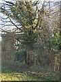
The start of a footpath by Heol-y-Sheet, nr North Cornelly
The gate in a fence seen in the image lies at the southern end of a public footpath. The course of some of that path as viewed from this spot is shown in Image
The country lane Heol-y-Sheet lies just the other side of the fence.
Image: © eswales
Taken: 24 Feb 2016
0.18 miles
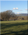
8
Farmland to the north of the M4 near Stormy Down
A view from the northern end of the bridge seen in Image
Image: © eswales
Taken: 4 Nov 2021
0.18 miles
9
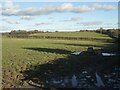
Public footpath off Heol-y-Sheet, nr North Cornelly
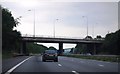
A picture taken at the southern end of a public footpath on the lane Heol-y-Sheet. The path is indistinct on the ground, but Ordnance Survey mapping shows it running directly to a field boundary location more or less where the prominent tree seen in the left of the image is situated. From there, the path passes through the gap in a fence seen beyond and across a bridge over the M4 motorway. The bridge, which can be made out just beyond the gap in the fence, is seen closer up in Image
When the photograph was taken, towards the end of a wet winter, the path was very squelchy in places .
Image: © eswales
Taken: 24 Feb 2016
0.18 miles