IMAGES TAKEN NEAR TO
Ton Kenfig, BRIDGEND, CF33 4PT
Introduction
This page details the photographs taken nearby to CF33 4PT by members of the Geograph project.
The Geograph project started in 2005 with the aim of publishing, organising and preserving representative images for every square kilometre of Great Britain, Ireland and the Isle of Man.

There are currently over 7.5m images from over14,400 individuals and you can help contribute to the project by visiting https://www.geograph.org.uk
Image Map
Images are licensed for reuse under creativecommons.org/licenses/by-sa/2.0
Notes
- Clicking on the map will re-center to the selected point.
- The higher the marker number, the further away the image location is from the centre of the postcode.
Image Listing (20 Images Found)
Images are licensed for reuse under creativecommons.org/licenses/by-sa/2.0
Image
Details
Distance
1
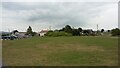
Kenfig
View from Kenfig Reserve Centre to the houses and village.
Image: © Colin Prosser
Taken: 21 Apr 2017
0.11 miles
3
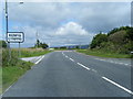
Other route with public access at Kenfig
This lane has the status of an ‘other route with public access’ in Ordnance Survey mapping (as denoted by the red dots on the 1: 50 000 map on this page, and green ones in 1: 25 000 mapping). A footpath sign is seen on the right hand side of it in the image. This lies at the western end of a stretch of public footpath to Heol-y-Broom, a lane which runs between South Cornelly and Mawdlam.
Image: © eswales
Taken: 1 Apr 2022
0.12 miles
4
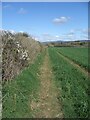
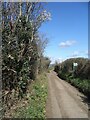
Public footpath between Kenfig and Heol-y-Broom
On the ground, the western half of this public footpath runs along the edge of a large farm field, taking a different course to that shown in Ordnance Survey maps.
The image shows the first stage of the path if started at its western end by the footpath sign seen in Image
Image: © eswales
Taken: 1 Apr 2022
0.13 miles
5
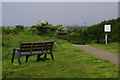
Path to Kenfig Pool
Kenfig National Nature Reserve stretches across the extensive dunes between here and the sea. The path in this view leads down from the car park to Kenfig Pool. In the distance is Port Talbot steelworks, much in the news when this photograph was taken.
Image: © Stephen McKay
Taken: 28 May 2016
0.15 miles
6
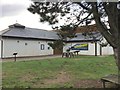
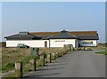
Kenfig Nature Reserve Centre
Kenfig Reserve Centre
Image: © Alan Hughes
Taken: 20 Dec 2015
0.15 miles
7
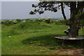
Kenfig National Nature Reserve
The view from close to the visitor centre, with Port Talbot steelworks in the distance.
Image: © Stephen McKay
Taken: 28 May 2016
0.16 miles
8
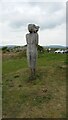
Kenfig Nature Reserve
Kenfig Nature Reserve, one of the wooden figures, they call The Watcher
Image: © Colin Prosser
Taken: 21 Apr 2017
0.16 miles
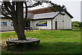
9
Kenfig Reserve Centre
An information and education centre for all things relevant to the extensive reserve centred on the lake and reed beds, the burrows and dunes in the area.
Image: © Mick Lobb
Taken: 26 Sep 2008
0.17 miles
10
Kenfig Visitor Centre
Kenfig National Nature Reserve covers a wide expanse of sand dunes, leading across to the sea. The car park and visitor centre are located on the Porthcawl - Kenfig road.
Image: © Stephen McKay
Taken: 28 May 2016
0.17 miles