IMAGES TAKEN NEAR TO
Maudlam, BRIDGEND, CF33 4PP
Introduction
This page details the photographs taken nearby to CF33 4PP by members of the Geograph project.
The Geograph project started in 2005 with the aim of publishing, organising and preserving representative images for every square kilometre of Great Britain, Ireland and the Isle of Man.

There are currently over 7.5m images from over14,400 individuals and you can help contribute to the project by visiting https://www.geograph.org.uk
Image Map
Images are licensed for reuse under creativecommons.org/licenses/by-sa/2.0
Notes
- Clicking on the map will re-center to the selected point.
- The higher the marker number, the further away the image location is from the centre of the postcode.
Image Listing (40 Images Found)
Images are licensed for reuse under creativecommons.org/licenses/by-sa/2.0
Image
Details
Distance
1
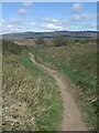
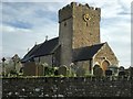
Duneland footpath by Mawdlam on Wales Coast Path relief section
This is one of a number of paths in a relief section of the Wales Coast Path followed when the route between Kenfig Burrows and Margam via Margam Moors is unusable because of flooding.
Image: © eswales
Taken: 1 Apr 2022
0.05 miles
2
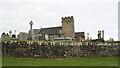
Kenfig
St Mary Magdalene church Kenfig
Image: © Colin Prosser
Taken: 20 Mar 2016
0.05 miles
3
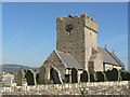
The Parish Church of St Mary Magdalene Kenfig
Image: © Mick Lobb
Taken: 26 Sep 2008
0.06 miles
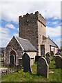
4
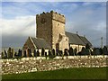
Saint Mary Magdalene Church, Mawdlam
Saint Mary Magdalene Church, Mawdlam - viewed from the southeast.
Image: © Alan Hughes
Taken: 20 Dec 2015
0.06 miles
5
Saint Mary Magdalene Church, Mawdlam
Saint Mary Magdalene Church at Mawdlam, viewed from the Southwest.
Image: © Alan Hughes
Taken: 20 Dec 2015
0.06 miles
6
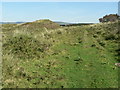
Reinforced footpath Kenfig Burrows
The path has been reinforced with concrete blocks.
Image: © Mick Lobb
Taken: 26 Sep 2008
0.07 miles
8
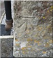
Ordnance Survey Cut Mark
This OS cut mark can be found on the NW face of St Mary Magdalen's Church. It marks a point 43.401m above mean sea level.
Image: © Adrian Dust
Taken: 14 Jul 2016
0.07 miles
9
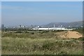
Margam steelworks from the start of one of the burrows' footpaths
Image: © Mick Lobb
Taken: 26 Sep 2008
0.07 miles
10
Saint Mary Magdalene Church, Mawdlam
Image: © Chris Andrews
Taken: 27 Apr 2022
0.07 miles