1
East side of Afon Y Felin Primary School, North Cornelly
Viewed across Marlas Road. The school entrance is from Heol y Parc.
Opened in 1977, the school, for children aged 4-11, has extensive grounds which include a rugby field, an environmental area and an orchard. There are about 90 children enrolled, in one of five classes.
The site includes a Flying Start building for pre-school learning and care for children aged up to 3.
Image: © Jaggery
Taken: 29 Nov 2012
0.05 miles
2
Traffic lights control the flow of traffic across Marlas Road railway bridge, Pyle
The bridge connects North Cornelly on this side of the South Wales main railway line
with Pyle on the far side. There is a 26 tonne weight limit on the bridge.
Image: © Jaggery
Taken: 29 Nov 2012
0.07 miles
3
Marlas Road railway bridge, Pyle
Though a few metres on the North Cornelly side of the Pyle boundary, the bridge's name is Pyle Marlas Road, identity 196m 57ch. The bridge carries Marlas Road over the South Wales main railway line 400 metres NW of Pyle railway station. There is a separate bridge on the left for pedestrians.
Image: © Jaggery
Taken: 29 Nov 2012
0.07 miles
4
The Afon Cynffig by Pyle and Marlas
Looking downstream from a grade II listed bridge lying on a public footpath.
Image: © eswales
Taken: 6 Oct 2012
0.07 miles
5
A view NW from Pyle railway station
Looking towards a road bridge nearly 300 metres away.
Image: © Jaggery
Taken: 29 Nov 2012
0.08 miles
6
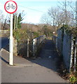
Marlas Road footbridge, Pyle
The footbridge is alongside the road bridge across the South Wales main railway line.
The red-edged sign means no cycling across the footbridge.
Image: © Jaggery
Taken: 29 Nov 2012
0.08 miles
7
Twisting section of lane at The Collwyn, Pyle
A lane twists at the western end of the strip of broadleaf woodland at The Collwyn.
The lane, which leads to a farm, is a private road along which a public footpath runs.
Image: © eswales
Taken: 15 Jun 2022
0.09 miles
8
Wooded valley of the Afon Cynffig, Pyle
The wooded valley known as The Collwyn seen close to Llanmihangel Mill (out of shot).
Image: © eswales
Taken: 15 Jun 2022
0.09 miles
9
Bridge over the Afon Cynffig , Pyle
A bridge near Llanmihangel Mill which has been a grade II listed building since April 2000 ( see http://www.britishlistedbuildings.co.uk/wa-23288-bridge-near-llanmihangel-mill-margam ).
Image: © eswales
Taken: Unknown
0.09 miles
10
L?n-y-Cariadon flats in North Cornelly
Three-storey flats set back from the north side of Ffordd yr Eglwys.
Image: © Jaggery
Taken: 4 Mar 2017
0.09 miles


