IMAGES TAKEN NEAR TO
Mountain View, BRIDGEND, CF33 4EH
Introduction
This page details the photographs taken nearby to Mountain View, CF33 4EH by members of the Geograph project.
The Geograph project started in 2005 with the aim of publishing, organising and preserving representative images for every square kilometre of Great Britain, Ireland and the Isle of Man.

There are currently over 7.5m images from over14,400 individuals and you can help contribute to the project by visiting https://www.geograph.org.uk
Image Map
Images are licensed for reuse under creativecommons.org/licenses/by-sa/2.0
Notes
- Clicking on the map will re-center to the selected point.
- The higher the marker number, the further away the image location is from the centre of the postcode.
Image Listing (34 Images Found)
Images are licensed for reuse under creativecommons.org/licenses/by-sa/2.0
Image
Details
Distance
1
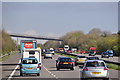
Bridgend District : The M4 Motorway
The M4 Motorway heading eastbound as it passes through the Bridgend area.
Image: © Lewis Clarke
Taken: 11 Apr 2014
0.07 miles
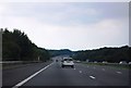
3
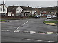
Slip road meeting roundabout at M4 Junction 37, North Cornelly
The road meeting the roundabout is the exit road for eastbound traffic on the motorway.
A vehicle heading eastwards on the motorway is seen near the left hand edge of the picture.
Image: © eswales
Taken: 15 Sep 2023
0.10 miles
4
Heol-y-Sheet public footpath, North Cornelly (4) – On the roundabout at M4 Junction 37
The path seen in the course of its rather tortuous passage across the roundabout en route to the more easterly of the two sections of Heol-y-Sheet. At this point it is descending from the level of a footbridge over the roundabout’s road which it has just passed across – see Image
Image: © eswales
Taken: 15 Sep 2023
0.11 miles
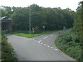
5
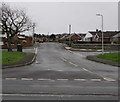
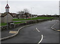
Maes-yr-haf Road, North Cornelly
Maes-yr-haf Road leads to an area of houses on the north side of the M4 motorway near junction 37.
The left turn behind the tree is into Heol Fawr. The right turn behind the lamppost is into Heol Neuadd.
Image: © Jaggery
Taken: 1 Mar 2017
0.14 miles
6
Woodland Place, North Cornelly
On the south side of Ffordd yr Eglwys.
Image: © Jaggery
Taken: 1 Mar 2017
0.15 miles
7
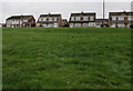
Heol Neuadd houses in North Cornelly
On top of a grassy bank above School Terrace.
Image: © Jaggery
Taken: 1 Mar 2017
0.17 miles
8
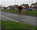
Bus stop and shelter opposite Ffordd yr Eglwys, North Cornelly
For buses to Porthcawl.
Image: © Jaggery
Taken: 1 Mar 2017
0.18 miles
9
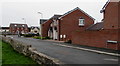
Clos Cae Ffynnon roadway towards a hump, North Cornelly
Cul-de-sac on the west side of Ffordd yr Eglwys.
Clos Cae Ffynnon is Welsh for Wellfield Close (or Springfield Close).
A sign warns that a hump is 50 yards ahead. The text is also in Welsh.
Image: © Jaggery
Taken: 1 Mar 2017
0.20 miles
10
Clos Cae Ffynnon, North Cornelly
On the west side of Ffordd yr Eglwys.
The monolingual name sign shows Clos Cae Ffynnon, Welsh for Wellfield Close (or Springfield Close).
Image: © Jaggery
Taken: 1 Mar 2017
0.20 miles