IMAGES TAKEN NEAR TO
Adams Avenue, BRIDGEND, CF32 9RX
Introduction
This page details the photographs taken nearby to Adams Avenue, CF32 9RX by members of the Geograph project.
The Geograph project started in 2005 with the aim of publishing, organising and preserving representative images for every square kilometre of Great Britain, Ireland and the Isle of Man.

There are currently over 7.5m images from over14,400 individuals and you can help contribute to the project by visiting https://www.geograph.org.uk
Image Map
Images are licensed for reuse under creativecommons.org/licenses/by-sa/2.0
Notes
- Clicking on the map will re-center to the selected point.
- The higher the marker number, the further away the image location is from the centre of the postcode.
Image Listing (36 Images Found)
Images are licensed for reuse under creativecommons.org/licenses/by-sa/2.0
Image
Details
Distance
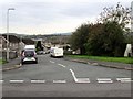
2
Bakers Way, Bryncethin
The southern end of Bakers Way viewed across Heol Canola.
Image: © Jaggery
Taken: 11 Oct 2018
0.15 miles
3
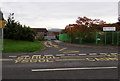
Keep Clear zone outside Flying Start, Sarn
On the north side of Heol Canola.
Image: © Jaggery
Taken: 11 Oct 2018
0.17 miles
4
Eustace Drive, Bryncethin
The southern end of Eustace Drive viewed across Heol Canola.
Image: © Jaggery
Taken: 11 Oct 2018
0.17 miles
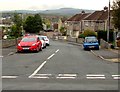
5
Junction of Heol Canola and Bakers Way, Bryncethin
Bakers Way https://www.geograph.org.uk/photo/5936881 from the left joins Heol Canola.
Image: © Jaggery
Taken: 11 Oct 2018
0.17 miles
6
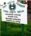
Coity Wallia Common notice, Canola near Sarn
Located here https://www.geograph.org.uk/photo/5939202 on the corner of Heol Canola and Park Place. The text is also in Welsh.
Image: © Jaggery
Taken: 11 Oct 2018
0.18 miles
7
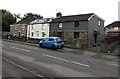
Row of three houses, Heol Canola, Bryncethin
The house on the right is named The Cottage.
Image: © Jaggery
Taken: 11 Oct 2018
0.18 miles
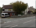
8
Queen Elizabeth II postbox, Heol Canola, Bryncethin
The corner of Eustace Drive is ahead.
Image: © Jaggery
Taken: 11 Oct 2018
0.18 miles
9
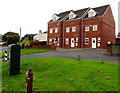
Row of three brick houses, Canola near Sarn
On the south side of Heol Canola. A dark green telecoms cabinet is on the left.
Image: © Jaggery
Taken: 11 Oct 2018
0.18 miles
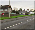
10
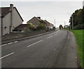
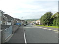
East along Heol Canola, Bryncethin
Towards the A4061 Bridgend Road. The broken white lines on the left are at the Bakers Way junction. https://www.geograph.org.uk/photo/5936881
Image: © Jaggery
Taken: 11 Oct 2018
0.18 miles