IMAGES TAKEN NEAR TO
Rhyd Lane, BRIDGEND, CF32 9PW
Introduction
This page details the photographs taken nearby to Rhyd Lane, CF32 9PW by members of the Geograph project.
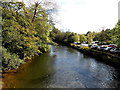
The Geograph project started in 2005 with the aim of publishing, organising and preserving representative images for every square kilometre of Great Britain, Ireland and the Isle of Man.

There are currently over 7.5m images from over14,400 individuals and you can help contribute to the project by visiting https://www.geograph.org.uk
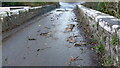
Image Map
Images are licensed for reuse under creativecommons.org/licenses/by-sa/2.0
Notes
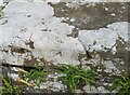
- Clicking on the map will re-center to the selected point.
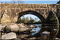
- The higher the marker number, the further away the image location is from the centre of the postcode.
Image Listing (78 Images Found)
Images are licensed for reuse under creativecommons.org/licenses/by-sa/2.0
Image
Details
Distance
1
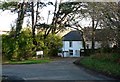
Fairwood House, Pen-y-fai - Bridgend
Location of TSW training services providing a variety of training needs.
Image: © Mick Lobb
Taken: 30 Nov 2009
0.01 miles
2

Beware - traffic approaching from the right, Pen-y-fai
The sign is on a grass triangle on the approach to TSW Training Ltd.
Image: © Jaggery
Taken: 10 Oct 2014
0.02 miles
4
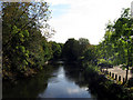
Tyrisha to Tyn y Garn
Tyrisha to Tyn y Garn river scene, the river Ogmore viewed towards the old stone bridge
Image: © Colin Prosser
Taken: 2 Apr 2021
0.03 miles
5
Tyn y Garn to Tyrisha
The lanes between Tyn y Garn and Tyrisha, the inscription on old stone bridge, over the river Ogmore, commonly known as Swanee Bridge, this was a former horse drawn tram road, to take coal from the valleys to Bridgend and onto Porthcawl for export
Image: © Colin Prosser
Taken: 26 Dec 2016
0.03 miles
6

Tyn y Garn
Tyn y Garn, viewed off Swanee bridge, tree felled in River Ogmore during Storm Eunice
Image: © Colin Prosser
Taken: 18 Feb 2022
0.04 miles
7
Tyn y Garn
Tyn y Garn, Swanee bridge, broken bits of branches of trees, on the bridge after Storm Eunice
Image: © Colin Prosser
Taken: 18 Feb 2022
0.04 miles
8
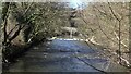
Downstream along the River Ogmore, Pen-y-fai
Viewed from a road bridge behind which is an M4 motorway overbridge. http://www.geograph.org.uk/photo/4636338
Image: © Jaggery
Taken: 10 Oct 2014
0.04 miles
9
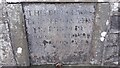
Ordnance Survey Rivet
This OS rivet can be found on the NW parapet of the bridge. It marks a point 35.467m above mean sea level.
Image: © Adrian Dust
Taken: 5 Sep 2021
0.04 miles
10
Pen y Cae Bridge
This bridge crosses the River Ogmore
Image: © John Finch
Taken: 20 Apr 2015
0.04 miles