IMAGES TAKEN NEAR TO
Hope Avenue, BRIDGEND, CF32 9PR
Introduction
This page details the photographs taken nearby to Hope Avenue, CF32 9PR by members of the Geograph project.
The Geograph project started in 2005 with the aim of publishing, organising and preserving representative images for every square kilometre of Great Britain, Ireland and the Isle of Man.

There are currently over 7.5m images from over14,400 individuals and you can help contribute to the project by visiting https://www.geograph.org.uk
Image Map
Images are licensed for reuse under creativecommons.org/licenses/by-sa/2.0
Notes
- Clicking on the map will re-center to the selected point.
- The higher the marker number, the further away the image location is from the centre of the postcode.
Image Listing (198 Images Found)
Images are licensed for reuse under creativecommons.org/licenses/by-sa/2.0
Image
Details
Distance
1
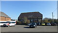
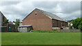
Aberkenfig
Aberkenfig Welfare Hall, viewed off Pandy Road, my Dad used to say when he was in colliery before World War 2, colliers donated 6 pence or 3 pence from their wages to build this
Image: © Colin Prosser
Taken: 6 Apr 2015
0.02 miles
2
Aberkenfig village
Welfare Hall, Aberkenfig, local miners contributed money from their wages to build
Image: © Colin Prosser
Taken: 20 Aug 2022
0.02 miles
3
Aberkenfig Welfare Hall
Viewed from the edge of Hope Avenue.
Image: © Jaggery
Taken: 27 Mar 2013
0.03 miles
4
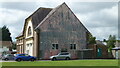
Aberkenfig Bible Church
The Pandy Road building was formerly the Lyric cinema, later a bingo hall.
Image: © Jaggery
Taken: 27 Mar 2013
0.03 miles
5
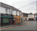
New Garden restaurant and Jasmine Takeaway, Aberkenfig
New Garden Chinese restaurant is at 40 Pandy Road.
Next door at 42 is Jasmine (Chinese cuisine) Takeaway.
The Village Fish Bar is in the background.
Image: © Jaggery
Taken: 27 Mar 2013
0.03 miles
6
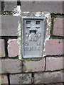
Ordnance Survey Flush Bracket (S9114)
This OS Flush Bracket can be found on the NW angle of the Hall. It marks a point 37.058m above mean sea level.
Image: © Adrian Dust
Taken: 9 Mar 2016
0.03 miles
7
Aberkenfig
Aberkenfig, formerly a Cinema called The Lyric, then during 1960's changed to a Bingo Hall, and now it is a Bible Study
Image: © Colin Prosser
Taken: 6 Apr 2015
0.03 miles
8
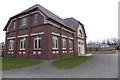
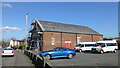
Police Station, Aberkenfig
The police station in Aberkenfig situated on Pandy Road.
Image: © Helen
Taken: 3 Feb 2015
0.04 miles
9
Aberkenfig village
The Lyric former cinema, later a Bingo Hall, now a religious meeting place.
Image: © Colin Prosser
Taken: 20 Aug 2022
0.04 miles
10
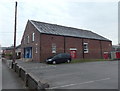
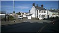
Pandy Road public toilets, Aberkenfig
The ladies' facilities are on the right, gents on the left.
Image: © Jaggery
Taken: 27 Mar 2013
0.04 miles