IMAGES TAKEN NEAR TO
Abergarw Road, BRIDGEND, CF32 9NZ
Introduction
This page details the photographs taken nearby to Abergarw Road, CF32 9NZ by members of the Geograph project.
The Geograph project started in 2005 with the aim of publishing, organising and preserving representative images for every square kilometre of Great Britain, Ireland and the Isle of Man.

There are currently over 7.5m images from over14,400 individuals and you can help contribute to the project by visiting https://www.geograph.org.uk
Image Map
Images are licensed for reuse under creativecommons.org/licenses/by-sa/2.0
Notes
- Clicking on the map will re-center to the selected point.
- The higher the marker number, the further away the image location is from the centre of the postcode.
Image Listing (21 Images Found)
Images are licensed for reuse under creativecommons.org/licenses/by-sa/2.0
Image
Details
Distance
1
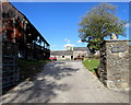
Entrance to Bryncethin Uchaf Farm, Bryncethin
From the A4061 Blackmill Road. Uchaf is Welsh for Upper(most).
Image: © Jaggery
Taken: 29 Oct 2018
0.14 miles
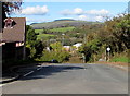
2
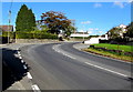
Bend in the A4061 Blackmill Road, Bryncethin
The A4061 ascends towards the northern edge of Bryncethin.
Image: © Jaggery
Taken: 29 Oct 2018
0.14 miles
3
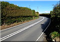
No overtaking on Blackmill Road north of Bryncethin
Double white lines in the middle of the A4061 Blackmill Road indicate no overtaking.
Image: © Jaggery
Taken: 29 Oct 2018
0.15 miles
4
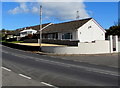
Bungalows at the northern edge of Bryncethin
Viewed across the A4061 Blackmill Road. Originally, bungalow was used in English for a lightly-built house, with a veranda and one storey. In current UK usage it is a convenient word for any one-storey dwelling.
Image: © Jaggery
Taken: 29 Oct 2018
0.15 miles
5
Ogmore Terrace, Bryncethin
North along Ogmore Terrace towards the A4065 and Abergarw.
Image: © Jaggery
Taken: 29 Oct 2018
0.20 miles
6
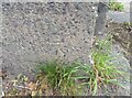
Ordnance Survey Cut Mark
This OS cut mark can be found on the NE parapet of Abergarw Bridge. It marks a point 56.912m above mean sea level.
Image: © Adrian Dust
Taken: 5 Sep 2021
0.21 miles
7
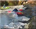
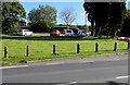
Messing about on the River
Members of the Bridgend Canoe Club play in the weir(s) on the Ogmore river at Brynmenyn.
Image: © Tim Morris
Taken: 19 Dec 2004
0.22 miles
9
Poppies on concrete posts, Blackmill Road, Bryncethin
On October 29th 2018 four or five poppies are on each concrete post alongside the A4061 Blackmill Road.
Image: © Jaggery
Taken: 29 Oct 2018
0.23 miles
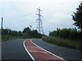
10
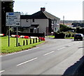
M4 motorway direction sign, Blackmill Road, Bryncethin
Stay on the A4061 for the M4 motorway and Bridgend or turn right ahead for the A4065 to Pontycymer.
Image: © Jaggery
Taken: 29 Oct 2018
0.23 miles