IMAGES TAKEN NEAR TO
Heol Laethog, BRIDGEND, CF32 9JE
Introduction
This page details the photographs taken nearby to Heol Laethog, CF32 9JE by members of the Geograph project.
The Geograph project started in 2005 with the aim of publishing, organising and preserving representative images for every square kilometre of Great Britain, Ireland and the Isle of Man.

There are currently over 7.5m images from over14,400 individuals and you can help contribute to the project by visiting https://www.geograph.org.uk
Image Map
Images are licensed for reuse under creativecommons.org/licenses/by-sa/2.0
Notes
- Clicking on the map will re-center to the selected point.
- The higher the marker number, the further away the image location is from the centre of the postcode.
Image Listing (4 Images Found)
Images are licensed for reuse under creativecommons.org/licenses/by-sa/2.0
Image
Details
Distance
1
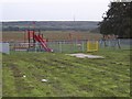
Children's play area
This play area is just a few yards from a small row of houses (to the north).
Image: © Roger
Taken: 30 Aug 2008
0.11 miles
2
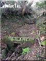
Sunken Lane
Old sunken lane and culvert at Heol Laethog. This track is marked on the OS map and is clearly visible at both ends, although overgrown and impassable now. Heol Laethog now winds up the slope more gently to the right of the farmhouse.
Image: © Alan Hughes
Taken: 18 Feb 2017
0.19 miles
3
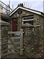
Abernathan House
Abernathan House, Heol Laethog.
Image: © Alan Hughes
Taken: 18 Feb 2017
0.19 miles
4
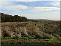
Hirwaun Common
This photograph is taken from the road north of the one crossing east to west across the common. In the distance the Rockwool insulation factory can just be made out.
Image: © Mick Lobb
Taken: 10 Oct 2008
0.23 miles