IMAGES TAKEN NEAR TO
Heol Y Glowyr, CF32 9FP
Introduction
This page details the photographs taken nearby to Heol Y Glowyr, CF32 9FP by members of the Geograph project.
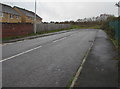
The Geograph project started in 2005 with the aim of publishing, organising and preserving representative images for every square kilometre of Great Britain, Ireland and the Isle of Man.

There are currently over 7.5m images from over14,400 individuals and you can help contribute to the project by visiting https://www.geograph.org.uk
Image Map
Images are licensed for reuse under creativecommons.org/licenses/by-sa/2.0
Notes
- Clicking on the map will re-center to the selected point.
- The higher the marker number, the further away the image location is from the centre of the postcode.
Image Listing (102 Images Found)
Images are licensed for reuse under creativecommons.org/licenses/by-sa/2.0
Image
Details
Distance
1
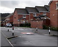
Cl?s Gwaith Brics, Tondu
Houses built in the second decade of the 21st century, part of a Llanmoor Homes development.
Image: © Jaggery
Taken: 27 Nov 2017
0.04 miles
2
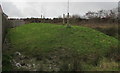
Saplings on a grassy mound, Tondu
Beyond the end of this road. https://www.geograph.org.uk/photo/6040093
Image: © Jaggery
Taken: 27 Nov 2017
0.05 miles
3
Brick houses, Cl?s Gwaith Brics, Tondu
Houses built in the second decade of the 21st century, part of a Llanmoor Homes development.
Image: © Jaggery
Taken: 27 Nov 2017
0.05 miles
4
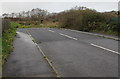
Western end of a side road, Tondu
The unnamed road ends here about 250 metres west of the A4063 Maesteg Road.
Image: © Jaggery
Taken: 27 Nov 2017
0.06 miles
5
Towards the end of the road, Tondu
An unnamed dead-end side road ascending from the west side of the A4063 Maesteg Road.
Image: © Jaggery
Taken: 27 Nov 2017
0.06 miles
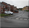
6
Traffic calming near Cl?s Gwaith Brics, Tondu
A speed bump and the narrowing of the roadway are in an area of recently-built houses.
Clôs Gwaith Brics https://www.geograph.org.uk/photo/5611855 is behind the camera.
Image: © Jaggery
Taken: 27 Nov 2017
0.07 miles
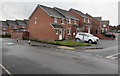
7
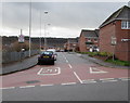
Start of the 20 zone near Cl?s Gwaith Brics, Tondu
The speed limit drops to 20mph through an area of recently-built houses.
The Clôs Gwaith Brics junction https://www.geograph.org.uk/photo/5611855 is on the right beyond the parked cars.
Image: © Jaggery
Taken: 27 Nov 2017
0.08 miles

10
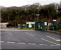
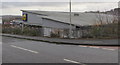
Kier Services Waste Transfer Station entrance, Tondu
From a dead-end road west of the A4063 Maesteg Road. The Kier Group website states
"Our Waste & Recycling and Household Waste and Recycling Centre (HWRC) contract for Bridgend County Borough Council started in 2010 and runs until 2024."
Image: © Jaggery
Taken: 27 Nov 2017
0.11 miles