IMAGES TAKEN NEAR TO
Heol-yr-Ysgol, BRIDGEND, CF32 9EG
Introduction
This page details the photographs taken nearby to Heol-yr-Ysgol, CF32 9EG by members of the Geograph project.
The Geograph project started in 2005 with the aim of publishing, organising and preserving representative images for every square kilometre of Great Britain, Ireland and the Isle of Man.

There are currently over 7.5m images from over14,400 individuals and you can help contribute to the project by visiting https://www.geograph.org.uk
Image Map
Images are licensed for reuse under creativecommons.org/licenses/by-sa/2.0
Notes
- Clicking on the map will re-center to the selected point.
- The higher the marker number, the further away the image location is from the centre of the postcode.
Image Listing (82 Images Found)
Images are licensed for reuse under creativecommons.org/licenses/by-sa/2.0
Image
Details
Distance
1
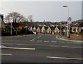
Junction of Heol Adare and Heol-yr-ysgol, Tondu
The 20mph speed limit on Heol-yr-ysgol near a school increases to 30mph on Heol Adare ahead.
This is one of two junctions of these roads in Tondu. The other one is 200 metres to the left (south).
Image: © Jaggery
Taken: 2 Dec 2017
0.02 miles
2
End of cycle route, Heol-yr-ysgol, Tondu
Blue signs show the end of a cycle route at a school entrance.
Image: © Jaggery
Taken: 10 Oct 2014
0.03 miles
3
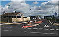
Turning circle at the end of Heol Caeglas, Tondu
Viewed from Heol-yr-ysgol.
Image: © Jaggery
Taken: 10 Oct 2014
0.03 miles
4
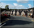
Heol Adare bungalows in Tondu
Heol Adare is a street on the west side of Heol-yr-ysgol.
Image: © Jaggery
Taken: 10 Oct 2014
0.05 miles
5
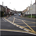
Yellow markings at a Tondu junction
At the junction of the A4065 Bryn Road and Heol-yr-ysgol on the left viewed in December 2017.
No yellow markings were here in a May 2016 Google Earth Street View.
Image: © Jaggery
Taken: 2 Dec 2017
0.07 miles
6
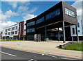
Coleg Cymunedol Y Dderwen, Tondu
Coleg Cymunedol Y Dderwen was created in 2011, when Ynysawdre Comprehensive School officially closed and its former students merged with those of Ogmore School. The school operated on a split-site basis during the two-year transitional period. From the start of the 2013-2014 academic year in September 2013, the school has occupied new buildings in Heol-yr-Ysgol, Ynysawdre, Tondu.
In view are buildings on the north side of the large site.
Image: © Jaggery
Taken: 10 Oct 2014
0.07 miles
7
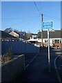
Cyclists Dismount sign on National Cycle Route 4 at Ynysawdre
The sign is for the attention of cyclists about to begin an off-road section of Cycle Route 4 by turning left at the other, more distant sign seen in the image. This will take them onto a public footpath, and it is probably the presence of blind 90° turns at either end of the initial short stretch of the path which explains the need to dismount, as well as, perhaps, the enclosed character and relative narrowness of that stretch.
Image: © eswales
Taken: 16 Jan 2023
0.07 miles
8
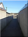
Public footpath on National Cycle Route 4, Ynysawdre
A short, enclosed stretch of a public footpath which lies on the long distance cycle route. Cyclists are meant to have dismounted when passing along this stretch of the path – see Image
Image: © eswales
Taken: 16 Jan 2023
0.07 miles
9
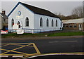
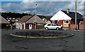
Ynysawdre Community Centre, Tondu
Viewed across the A4065 Bryn Road from the corner of Heol-yr-ysgol.
Built as a Mission Hall c1900. Bryn Road Chapel is on the right. http://www.geograph.org.uk/photo/5620902
Image: © Jaggery
Taken: 2 Dec 2017
0.08 miles
10
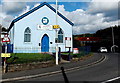
Ynysawdre Community Centre, Tondu
Viewed across the A4065 Bryn Road.
Image: © Jaggery
Taken: 10 Oct 2014
0.08 miles